Файл:Anglo American War 1812 Locations map-en.svg

Исходный файл (SVG-файл, номинально 1052 × 744 пкс, размер файла: 136 Кб)
Этот файл находится на Викискладе. Сведения о нём показаны ниже.
Викисклад — централизованное хранилище для свободных файлов, используемых в проектах Викимедиа.
|
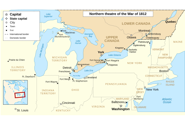
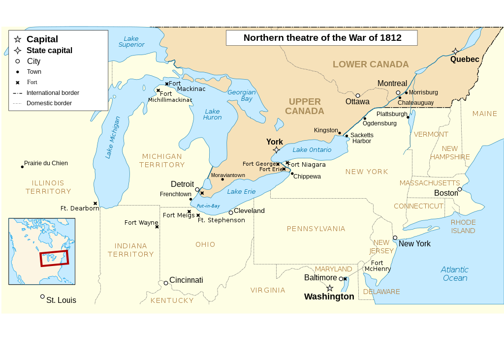
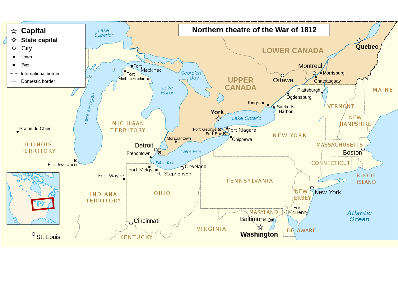
The map omits two of the most important battles of the war as far as the territorial outcome of the Treaty of Ghent. The Battle of Lake Erie (aka Battle of Put in Bay) was where the entire British Upper Great Lakes Fleet surrendered. With the Great Lakes supply lines cut, the British and their Indian allies destroyed the forts at Detroit and Amherstburg and tried to retreat up the Thames River hoping to reach the main British base at Burlington on Lake Ontario.The American army under General Harrison caught up with them at Moraviantown and the British were defeated. Most important was that Tecumseh was killed at this battle and, with his death, the Indian Confederation fell apart and thousands of the warriors just went home. When the Duke of Wellington, fresh from defeating Napoleon, was subsequently offered command of the British Army in America, he said he'd go but couldn't promise anything unless the Navy first got control of the Great Lakes. Otherwise, he told the negotiators that they may as well give up on any territorial demands and just make peace with the US. See "Three Strikes in the War of 1812".
| Описание |
English: Main locations of the War of 1812 between the United States and the United Kingdom Français : Principaux théâtres d'opérations de la Guerre de 1812 entre les États-Unis et le Royaume-Uni. Español: Principales teatros de operaciones de la Guerra de 1812 entre los Estados Unidos y el Reino Unido. |
| Дата | (UTC) |
| Источник | |
| Автор |
|
| Другие версии |
Производные работы от этого файла: |
| Это отретушированное изображение, что означает, что первоначальной версия изображения была изменена цифровым способом. Изменения: translated to english. Оригинал доступен по ссылке: Anglo American War 1812 Locations map-fr.svg:
|
- Вы можете свободно:
- делиться произведением – копировать, распространять и передавать данное произведение
- создавать производные – переделывать данное произведение
- При соблюдении следующих условий:
- атрибуция – Вы должны указать авторство, предоставить ссылку на лицензию и указать, внёс ли автор какие-либо изменения. Это можно сделать любым разумным способом, но не создавая впечатление, что лицензиат поддерживает вас или использование вами данного произведения.
- распространение на тех же условиях – Если вы изменяете, преобразуете или создаёте иное произведение на основе данного, то обязаны использовать лицензию исходного произведения или лицензию, совместимую с исходной.

|
Разрешается копировать, распространять и/или изменять этот документ в соответствии с условиями GNU Free Documentation License версии 1.2 или более поздней, опубликованной Фондом свободного программного обеспечения, без неизменяемых разделов, без текстов, помещаемых на первой и последней обложке. Копия лицензии включена в раздел, озаглавленный GNU Free Documentation License. |
Исходный журнал загрузок
This image is a derivative work of the following images:
- File:Anglo_American_War_1812_Locations_map-fr.svg licensed with Cc-by-sa-3.0,2.5,2.0,1.0, GFDL
- 2008-06-20T23:26:18Z MaCRoEco 1494x830 (154198 Bytes) {{Information |Description= |Source= |Date= |Author= |Permission= |other_versions= }}
- 2008-06-17T16:04:43Z Sémhur 1494x830 (163461 Bytes) Mistake : Fort Henry => Fort McHenry
- 2008-06-17T09:50:41Z Sémhur 1494x830 (163245 Bytes) {{Information |Description={{en|1=Main locations of the [[:en:War of 1812|War of 1812]] between the United States and the United Kingdom}} {{fr|1=Principaux théâtres d'opérations de la [[:fr:Guerre de 1812|Guerre de 1812]]
Uploaded with derivativeFX
История файла
Нажмите на дату/время, чтобы посмотреть файл, который был загружен в тот момент.
| Дата/время | Миниатюра | Размеры | Участник | Примечание | |
|---|---|---|---|---|---|
| текущий | 00:52, 6 марта 2023 | | 1052 × 744 (136 Кб) | Hunter9502 | Reverted to version as of 08:55, 7 February 2021 (UTC) - February 2023 version has broken SVG formatting |
| 00:15, 4 февраля 2023 |  | 1600 × 915 (493 Кб) | Yourlocallordandsavior | Removed useless sections. | |
| 08:55, 7 февраля 2021 |  | 1052 × 744 (136 Кб) | Kevin1776 | Added requested missing locations (Moraviantown, Put-in-Bay), moved Fort Meigs to correct locations, other font & readability adjustments. | |
| 18:03, 25 июля 2011 |  | 1494 × 830 (128 Кб) | Amirki | minor color change | |
| 21:05, 22 января 2011 |  | 1494 × 830 (153 Кб) | P. S. Burton | {{Information |Description={{en|1=Main locations of the War of 1812 between the United States and the United Kingdom}} {{fr|1=Principaux théâtres d'opérations de la Guerre de 1812 entre les États-Unis et le R |
Использование файла
Следующие 3 страницы используют этот файл:
Глобальное использование файла
Данный файл используется в следующих вики:
- Использование в af.wikipedia.org
- Использование в de.wikipedia.org
- Использование в en.wikipedia.org
- Использование в gd.wikipedia.org
- Использование в he.wikipedia.org
- Использование в hr.wikipedia.org
- Использование в ro.wikipedia.org
- Использование в sv.wikipedia.org
- Использование в vi.wikipedia.org