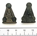
Файл:Anglo Saxon Die for Pressblech foils (FindID 493755).jpg

Исходный файл (2406 × 2362 пкс, размер файла: 570 КБ, MIME-тип: image/jpeg)
Этот файл находится на Викискладе. Сведения о нём показаны ниже.
Викисклад — централизованное хранилище для свободных файлов, используемых в проектах Викимедиа.
Сообщить об ошибке с файлом |
Краткое описание
| Anglo Saxon Die for Pressblech foils | |||
|---|---|---|---|
| Фотограф |
Durham County Council, Emma Morris, 2012-03-14 11:54:49 |
||
| Название |
Anglo Saxon Die for Pressblech foils |
||
| Описание |
English: A complete cast copper-alloy die of Early Anglo-Saxon date (late 6th-7th centuries AD). It is flat and triangular, and consists of a central panel surrounded by a border. The central panel is decorated in low relief with a double-strand interlace pattern. The border consists of a line of dots in between two relief lines. The border is interrupted by three flat undecorated circles, one at each point of the triangle. The metal is green and the object is in good condition. The reverse is undecorated. It weighs 3.1g and measures 25.46mm in length, 17.63mm at its widest point and 2.19mm.
Kevin Leahy kindly identified this object and writes 'It is Anglo-Saxon and of later sixth/seventh century date and it looks like a die for making Pressblech foils for use on three-rivet triangular buckle plates. The best parallel is an example from the Isle of Wight, IOW-3AB946, which has a more elaborate decoration but is basically similar.' Also see HAMP-BAA204. |
||
| Изображённое место | (County of findspot) North Yorkshire | ||
| Дата | между 575 и 650 | ||
| Инвентарный номер |
FindID: 493755 Old ref: DUR-0850C3 Filename: DUR-0850C3.jpg |
||
| Дополнительная информация |
|
||
| Источник |
https://finds.org.uk/database/ajax/download/id/374011 Catalog: https://finds.org.uk/database/images/image/id/374011/recordtype/artefacts archive copy at the Wayback Machine Artefact: https://finds.org.uk/database/artefacts/record/id/493755 |
||
| Права (Повторное использование этого файла) |
Attribution-ShareAlike License version 4.0 (verified 28 ноября 2020) | ||
| Местоположение объекта | 54° 29′ 20,4″ с. ш., 1° 45′ 38,09″ з. д. | Это и другие изображения по их местоположению на OpenStreetMap |
|---|
Лицензирование
- Вы можете свободно:
- делиться произведением – копировать, распространять и передавать данное произведение
- создавать производные – переделывать данное произведение
- При соблюдении следующих условий:
- атрибуция – Вы должны указать авторство, предоставить ссылку на лицензию и указать, внёс ли автор какие-либо изменения. Это можно сделать любым разумным способом, но не создавая впечатление, что лицензиат поддерживает вас или использование вами данного произведения.
- распространение на тех же условиях – Если вы изменяете, преобразуете или создаёте иное произведение на основе данного, то обязаны использовать лицензию исходного произведения или лицензию, совместимую с исходной.
Краткие подписи
Элементы, изображённые на этом файле
изображённый объект
54°29'20"N, 1°45'40"W
0,0125 секунда
18,098 миллиметр
image/jpeg
e6136b42fd5bd4ece877e1504f293c71f10468dd
583 402 байт
2362 пиксель
2406 пиксель
История файла
Нажмите на дату/время, чтобы посмотреть файл, который был загружен в тот момент.
| Дата/время | Миниатюра | Размеры | Участник | Примечание | |
|---|---|---|---|---|---|
| текущий | 09:17, 1 февраля 2017 |  | 2406 × 2362 (570 КБ) | Fæ | Portable Antiquities Scheme, DUR, FindID: 493755, early medieval, page 290, batch North+Yorkshire count 87 |
Использование файла
Следующая страница использует этот файл:
Метаданные
Файл содержит дополнительные данные, обычно добавляемые цифровыми камерами или сканерами. Если файл после создания редактировался, то некоторые параметры могут не соответствовать текущему изображению.
| Производитель камеры | Canon |
|---|---|
| Модель камеры | Canon PowerShot G10 |
| Время экспозиции | 1/80 с (0,0125) |
| Число диафрагмы | f/4 |
| Светочувствительность ISO | 200 |
| Оригинальные дата и время | 15:21, 15 февраля 2012 |
| Фокусное расстояние | 18,098 мм |
| Ориентация кадра | Нормальная |
| Горизонтальное разрешение | 600 точек на дюйм |
| Вертикальное разрешение | 600 точек на дюйм |
| Программное обеспечение | Adobe Photoshop 7.0 |
| Дата и время изменения файла | 13:21, 23 февраля 2012 |
| Порядок размещения компонент Y и C | CO-sited |
| Версия Exif | 2.21 |
| Дата и время оцифровки | 15:21, 15 февраля 2012 |
| Конфигурация цветовых компонентов |
|
| Глубина цвета после сжатия | 5 |
| Выдержка в APEX | 6,3125 |
| Диафрагма в APEX | 4 |
| Компенсация экспозиции | 0 |
| Минимальное число диафрагмы | 4 APEX (f/4) |
| Режим замера экспозиции | Матричный |
| Статус вспышки | Вспышка не срабатывала, автоматический режим |
| Поддерживаемая версия FlashPix | 1 |
| Цветовое пространство | sRGB |
| Разрешение по X в фокальной плоскости | 15 123,287671233 |
| Разрешение по Y в фокальной плоскости | 15 123,287671233 |
| Единица измерения разрешения в фокальной плоскости | дюймов |
| Тип сенсора | Однокристальный матричный цветной сенсор |
| Источник файла | Цифровой фотоаппарат |
| Дополнительная обработка | Не производилась |
| Режим выбора экспозиции | Автоматическая экспозиция |
| Баланс белого | Автоматический баланс белого |
| Коэффициент цифрового увеличения (цифровой зум) | 1 |
| Тип сцены при съёмке | Стандартный |
| Версия IIM | 2 |
