Файл:Aras River, Turkey-Armenia-Iran Border Region.JPG

Исходный файл (4288 × 2848 пкс, размер файла: 13,14 Мб, MIME-тип: image/jpeg)
Этот файл находится на Викискладе. Сведения о нём показаны ниже.
Викисклад — централизованное хранилище для свободных файлов, используемых в проектах Викимедиа.
|
Краткое описание
| Описание |
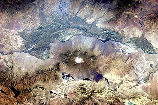
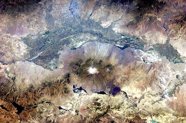
English: This astronaut photograph, taken from the International Space Station, highlights a segment of the international border between Armenia and Turkey. The Aras River separates the two countries, with Armenia to the north-north-east and Turkey to the south-south-west. Extensive green agricultural fields are common on both sides of the river (upper part of image), as well as a number of gray-to-tan urban areas including Yerevan (image top, slightly left of centre) and Artashat and Armavir in Armenia, and Iğdır in Turkey. While there have been efforts to normalize diplomatic relations between the two countries in recent years, the Armenia-Turkey border remains officially closed.
The dominant geographic feature in the region is Mt. Ararat, also known as Agri Dagi. The peak of Ararat, a large stratovolcano that last erupted in 1840 according to historical records, is located approximately 40 kilometres to the south of the Armenia-Turkey border. A lower peak to the east, known as Lesser or Little Ararat, is also volcanic in origin. Dark gray lava flows to the south of Mt. Ararat are located near the Turkish border with Iran. While this border is also closed along much of its length, official crossing points allow relatively easy travel between the two countries. The white, glacier-clad peak of Mt. Ararat is evident at image centre; dark green areas on the lower slopes indicate where vegetation cover is abundant. A large lake, Balik Golu or Fish Lake, is visible to the west (image lower left). |
| Дата | |
| Источник | NASA Earth Observatory |
| Автор | ISS Expedition 28 crew |
| Местоположение камеры | | Это и другие изображения по их местоположению на OpenStreetMap |
|---|
Это изображение или видеозапись внесены в каталог Космического центра имени Джонсона НАСА под идентификатором (Photo ID): ISS028-E-15023. Этот шаблон не указывает на правовой статус данной работы. По-прежнему необходим нормальный шаблон лицензий. См. Commons:Лицензирование. Другие языки:
|
Image acquired with a Nikon D2Xs digital camera using a 65 mm lens, and is provided by the ISS Crew Earth Observations experiment and Image Science & Analysis Laboratory, Johnson Space Center.
Лицензирование
| Этот файл находится в общественном достоянии (англ. public domain), так как он был создан NASA (Национальным управлением по аэронавтике и исследованию космического пространства). Политика авторского права NASA гласит, что «Материал NASA не защищается авторским правом, если не указано иное». (См. Template:PD-USGov, страницу политики авторского права NASA или политику использования изображений JPL.) | ||
 |
Предупреждения:
|
| Аннотации | Это изображение аннотировано: Просмотреть аннотации на Викискладе |
История файла
Нажмите на дату/время, чтобы посмотреть файл, который был загружен в тот момент.
| Дата/время | Миниатюра | Размеры | Участник | Примечание | |
|---|---|---|---|---|---|
| текущий | 18:37, 25 июля 2011 | | 4288 × 2848 (13,14 Мб) | Originalwana | {{Information |Description ={{en|1=This astronaut photograph, taken from the International Space Station, highlights a segment of the international border between Armenia and Turkey. The Aras River separates the two countries, with Armenia |
Использование файла
Следующая страница использует этот файл:
Глобальное использование файла
Данный файл используется в следующих вики:
- Использование в af.wikipedia.org
- Использование в ar.wikipedia.org
- Использование в ast.wikipedia.org
- Использование в avk.wikipedia.org
- Использование в bn.wikipedia.org
- Использование в ca.wikipedia.org
- Использование в en.wikipedia.org
- Использование в es.wikipedia.org
- Использование в fa.wikipedia.org
- Использование в fi.wikipedia.org
- Использование в gl.wikipedia.org
- Использование в hsb.wikipedia.org
- Использование в hy.wikipedia.org
- Использование в hyw.wikipedia.org
- Использование в it.wikipedia.org
- Использование в ja.wikipedia.org
- Использование в ka.wikipedia.org
- Использование в ku.wikipedia.org
- Использование в ml.wikipedia.org
- Использование в pt.wikipedia.org
- Использование в ro.wikipedia.org
- Использование в sk.wikipedia.org
- Использование в sl.wikipedia.org
- Использование в sv.wikipedia.org
- Использование в tr.wikipedia.org
- Использование в ur.wikipedia.org
- Использование в uz.wikipedia.org