Файл:Great Lakes 1913 Storm Shipwrecks.png

Исходный файл (4000 × 2400 пкс, размер файла: 799 Кб, MIME-тип: image/png)
Этот файл находится на Викискладе. Сведения о нём показаны ниже.
Викисклад — централизованное хранилище для свободных файлов, используемых в проектах Викимедиа.
|
Краткое описание
| Описание |
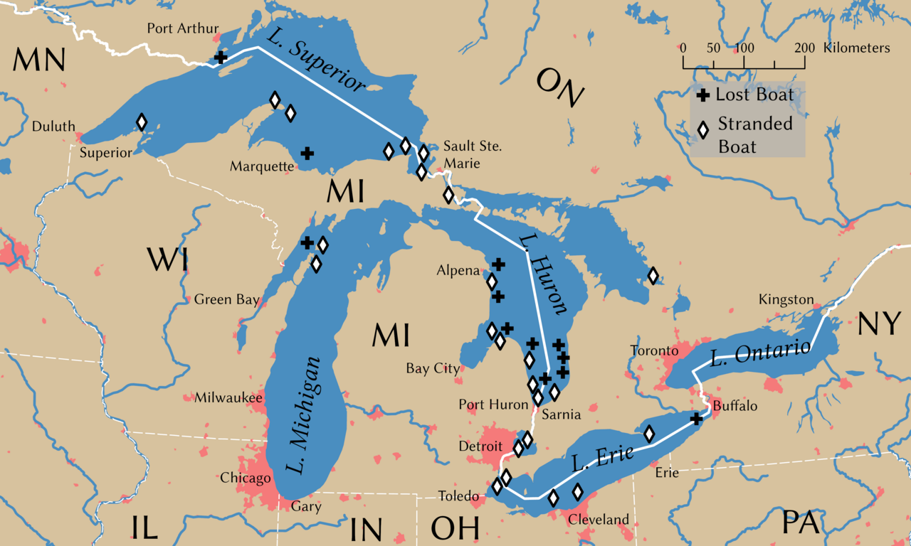
English: Shipwrecks during the Great Lakes Storm of 1913. Wreck locations come from Brown (2002, p. 203) |
||
| Дата | |||
| Источник | Собственная работа | ||
| Создатель | |||
| Дополнительная информация | © Tom Fish, geo.fish // Creative Commons BY-SA 4.0 | ||
| Права (Повторное использование этого файла) |
|
||
| Geotemporal data | |||
| Система пространственной привязки | NAD 1983 Great Lakes Basin Albers [WKID: 31734] | ||
| Масштаб | 1:11,792,324 | ||
| Archival data | |||
| artwork-references | Brown, David G. (2002) White Hurricane: A Great Lakes November Gale and America's Deadliest Maritime Disaster, International Marine/McGraw-Hill ISBN: 0-07-138037-X. | ||
| PNG‑разработка | Это map было создано с помощью ArcGIS Pro |
||
Лицензирование
Data
Rivers, lakes, and urban areas
| This file uses data that was sourced from Natural Earth, a public domain dataset. From the terms of use:
All versions of Natural Earth raster + vector map data found on this website are in the public domain. You may use the maps in any manner, including modifying the content and design, electronic dissemination, and offset printing. The primary authors, Tom Patterson and Nathaniel Vaughn Kelso, and all other contributors renounce all financial claim to the maps and invites you to use them for personal, educational, and commercial purposes. |
Shipwreck locations
The locations of the shipwrecks are facts and are not eligible for copyright protection
| Это произведение не защищается авторским правом, так как является тривиальным, не несёт художественной ценности, состоит только из общеизвестных элементов, не имеющих авторства. |
International boundary
The international boundaries are sourced from the Large Scale International Boundaries published by the US Department of State
| This image is a work of a United States Department of State employee, taken or made as part of that person's official duties. As a work of the U.S. federal government, the image is in the public domain per 17 U.S.C. § 101 and § 105 and the Department Copyright Information. |  |
State boundary
The state boundaries are sourced from STATE_BOUNDS the United States Geological Survey
Это изображение находится в общественном достоянии, так как содержит материалы, которые первоначально получены от Геологической службы США (USGS) — агентства Министерства внутренних дел США. Дополнительную информацию см. «Официальная политика авторского права USGS» (англ.).
|
Final Map
- Вы можете свободно:
- делиться произведением – копировать, распространять и передавать данное произведение
- создавать производные – переделывать данное произведение
- При соблюдении следующих условий:
- атрибуция – Вы должны указать авторство, предоставить ссылку на лицензию и указать, внёс ли автор какие-либо изменения. Это можно сделать любым разумным способом, но не создавая впечатление, что лицензиат поддерживает вас или использование вами данного произведения.
- распространение на тех же условиях – Если вы изменяете, преобразуете или создаёте иное произведение на основе данного, то обязаны использовать лицензию исходного произведения или лицензию, совместимую с исходной.
История файла
Нажмите на дату/время, чтобы посмотреть файл, который был загружен в тот момент.
| Дата/время | Миниатюра | Размеры | Участник | Примечание | |
|---|---|---|---|---|---|
| текущий | 23:54, 8 ноября 2021 | | 4000 × 2400 (799 Кб) | Guerillero | Remedy copyright issues |
| 19:07, 27 февраля 2007 |  | 1786 × 1194 (1,05 Мб) | SalomonCeb | Shipwrecks during the en:Great Lakes Storm of 1913. Reference: ''White Hurricane'', by David G. Brown, 2002. All text and icons were added to the PD blank map located at: http://walrus.wr.usgs.gov/infobank/gazette/jpg/regions/fr_glez.jpg {{PD-s |
Использование файла
Следующая страница использует этот файл:
Глобальное использование файла
Данный файл используется в следующих вики:
- Использование в ca.wikipedia.org
- Использование в de.wikipedia.org
- Использование в de.wiktionary.org
- Использование в en.wikipedia.org
- Использование в fr.wikipedia.org
- Использование в nl.wikipedia.org
- Использование в uz.wikipedia.org