Файл:Old map 1807 plan.jpg
Исходный файл (1004 × 1192 пкс, размер файла: 519 КБ, MIME-тип: image/jpeg)
Этот файл находится на Викискладе. Сведения о нём показаны ниже.
Викисклад — централизованное хранилище для свободных файлов, используемых в проектах Викимедиа.
|
Краткое описание
| Описание |
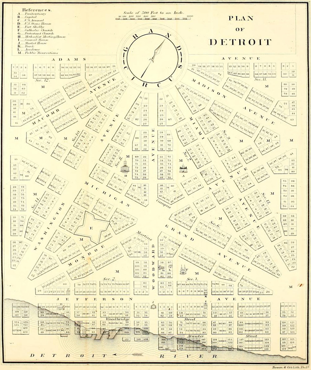
English: Detroit city layout plan circa 1807—following the 1805 fire that destroyed most of the city. The map shows Grand Circus Park (top), and some of the present-day Grand Circus Park Historic District. |
| Дата | около 1807 |
| Источник | Dickens, Asbury & Forney, John W., eds. (1832) "Plan of Detroit" (Map). American State Papers. Vol. 6: Public Lands. 1:6,000. Washington, DC: Gales & Seaton. p. 299. OCLC 2053058. OL7014594M. LCCN 09033892. – via Archive.org. |
| Автор | Неизвестен |
Лицензирование
Это изображение находится в общественном достоянии (англ. public domain), так как это просто механический скан или фотокопия оригинала, находящегося в общественном достоянии или – по имеющимся доказательствам – является до такой степени похожим на такой скан или фотокопию, что нельзя ожидать возникновение защиты авторским правом. Собственно оригинал находится в общественном достоянии по следующей причине:
Этот тэг разработан для использования там, где может возникнуть необходимость утверждать, что любые улучшения (например, яркость, контраст, совпадение цветов, резкость) являются сами по себе недостаточно творческими для порождения нового авторского права. Он может быть использован там, где неизвестно были ли сделаны какие-либо улучшения, а также когда улучшения ясны, но недостаточны. Для известных неулучшенных сканов в исходном формате вы можете использовать подходящий тэг {{PD-old}} вместо этого. Для использования, см. Commons:When to use the PD-scan tag.  |


История файла
Нажмите на дату/время, чтобы посмотреть файл, который был загружен в тот момент.
| Дата/время | Миниатюра | Размеры | Участник | Примечание | |
|---|---|---|---|---|---|
| текущий | 05:18, 4 апреля 2013 | | 1004 × 1192 (519 КБ) | Imzadi1979 | perspective correction and cropped to remove whitespace |
| 16:46, 22 сентября 2012 |  | 1115 × 1348 (260 КБ) | Imzadi1979 | higher resolution version with known source information | |
| 14:54, 8 июля 2007 |  | 655 × 937 (146 КБ) | DeltaWeb~commonswiki | == Summary == Detroit city layout circa 1807 following the 1805 fire that destroyed most of the city. From the Detroit Historical Museum site == Licensing == {{PD-US}} Category:Michigan maps Category:Images of Detroit, Michigan [[Category:Images |
Использование файла
Следующая страница использует этот файл:
Глобальное использование файла
Данный файл используется в следующих вики:
- Использование в ar.wikipedia.org
- Использование в en.wikipedia.org
- M-1 (Michigan highway)
- Campus Martius Park
- History of Detroit
- Augustus B. Woodward
- Grand Circus Park Historic District
- Gabriel Richard
- Washington Boulevard Historic District
- Roads and freeways in metropolitan Detroit
- National Register of Historic Places listings in Detroit
- Transportation in metropolitan Detroit
- User:Andrew Jameson/Detroit2
- User:Andrew Jameson/Detroit1
- National Register of Historic Places listings in Downtown and Midtown Detroit
- File talk:Old map 1807 plan.jpg
- Great Fire of 1805
- Использование в es.wikipedia.org
- Использование в fa.wikipedia.org
- Использование в fr.wikipedia.org
- Использование в gl.wikipedia.org