Исходный файл(SVG-файл, номинально 1390 × 1295 пкс, размер файла: 488 Кб)

 
W3C-validity not checked.

Краткое описание

Описание

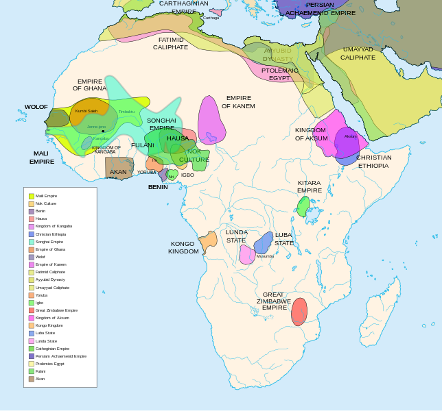
Africa History Atlas

Diachronic map showing pre-colonial cultures of Africa (spanning roughly 500 BCE to 1500 CE)

This map is "an artistic interpretation" using multiple and disparate sources.
Дата
Источник Собственная работа
Автор Jeff Israel (ZyMOS)
Другие версии

Производные работы от этого файла:  African-civilizations-map-imperial.png

Civilizations

These civilizations are shown on the map above

Mali Empire (done):
        [4], [5], [6], [7], [8](1300), 14

Nok Culture(done):
        http://perso.orange.fr/miltiade/Civilisation_de_Nok.htm
        [5]

Fulani empire (aka sokoto empire, Sokoto Calphate, Fulani Empire of Sokoto)  (fulani people are different) (done):
        [2], [10e], [11e]
Akan States (generric term for states with the akan people)(Done): 
 [7], 
Benin: (done)
        [7],[14],[16]
Hausa (done)
        [7], [10],[16]

Kingdon of Kangaba (1000AD?) (done)
        [8](1235)

Christian Ethiopia(done)
        [5]

Songhai Empire (done)
        http://commons.wikimedia.org/wiki/Image:Mapa_shonghai.svg
        [3], [4], [5], [6], [7], [8](1300), [16]
        http://www.zum.de/whkmla/histatlas/westafrica/haxmali.html
        http://empathosnationenterprises.com/Consulate/EN-Library/Black-Studies/afempire.html

Empire of Ghana (done):
        [4], [5], [6], [7]

Wolof: (15th century) (done)
        [2],[2c],[14]

Empire of Kanem:(done)
        [15]

Fatimid caliphate(done) 909-1171AD
        [2b],[6b]

Ayyubid dynasty (done) 1171-1250ad
        [1b], [5e], [6e]

Umayyad Caliphate (done) 661-750
        [5b]

Yoruba yorubaland    (done)
        [4b],[2c]

Igbo    (done)
        [4b],

Great Zimbabwe (done):
        [5], [7]

Kingdom of aksum (Axum?) 1bc-7ad  (done)
        [12b],[14b],[15b]

Kongo Kingdom     (done)
        [1c], [2c],[15]

Luba State (done) 15-19th century
        [2c],[4c]

Lunda State (done) 15-19th century
        [2c],[4c],[16]

Carthaginian Empire(done) (220BCE) Carthage
        [2c], [3c]

Persian Achaemenid Empire (done)
        [2e],3e].4e],[

THE PTOLEMIES (done)
        [8e], [9e]

Civilizations to be added

These civilizations have not been added because the borders have not yet been confirmed, or there is some uncertainty if they are a true civilization. Please add them to the map if you are able to define the borders of these civilizations.


Mane (1000-2000)(city) [41]

Kano (independent city-state) (1000-1903):
 [14]

Kaarta (kingdom of Kaarta) (1753-1854):
 [14]

Macina (Macina Empire) (aka Dina of Massina, Sise Jihad state, and Caliphate of Hamdullahi) (1818-1862):
 [14]

Segou (city 1620):
 [14]

Kingdom of Fouta Djallon (Futa Djalon or Kingdom of Fuuta Jallon):
 [14]

Hausa Bakwai (initial stage Hausa):
 [11e]

Wassoulou Empire (Ouassoulou) (1878 - 1898) :
 [14]

Kénédougou Kingdom (Kenedougou) (1650-1898):
 [14]

Ouagadougou (15th century CITY):
 [14]

Ashanti Kingdom:
	[14]

Dahomey:
	[14]

Gando (16th century town):
	[14]

kingdom of Takrur (c. 800 - c. 1285) :
	[8](1300), [13]

Oyo empire (1400-1796)


Bornu Empire (1396-1893):
        [2],[15], [10e]

Bornu-Kanem (a portion of kanem history where they merged):
	[7],[2c]

Wodaabe (a people of africa):
	[10]

Mamluk Sultanate of Egypt (1174-1820):
	[2],[12], 

Kush?Kushite kingdom?:

Axum (see kingdom of aksum):

Buganda kingdom (changed to Unganda, but remained as Buganda people):

Lozi???:

Malawi Empire (late 15th centure and converted to Malawi Contry):

Kilwa (Kilwa Kisiwani, 9th century,  is an Islamic community is present day tanzania):
	[2c]

Abyssinia???:
        [2], [7]

Soha????:
        [2],

Nubia (Makuria, Nobatia, Alodia kingdom):
	[7], 

Kingdom of Kerma(2500BC-1520BC):

=North Central=

Sahariano??:
	[1], 

Maban????????:
        [1],

Fur(a people:
        [1],

Sudanes Central (language Central Sudanic):
        [1],

=East Central=

Sudanes Meridional???:
        [1],

Berta(language>:
        [1],

Kunama(a people):
        [1],

Komuz???instument:
        [1],

Aksumite Civilization
	[7b], [9b(maybey], [13b(aksum)]

Kingdom of Sheva???
	[8b]

Egypt
	[10b]

JolofEmpire (also called Dyolof or Wolof), wolof should be changed to this:
	[11b]


Meroe(city, capital of Kushitic Kingdom)) 
	[12b]

Bantu(ethnic group)
	[12b]

Khoisan(ethnic group)
	[12b]

Almoravid Empire
	[5c], [1f]
	
Monomotapa
	[2c],[16]

Lozi
	[2c]

Zulu Kingdom
	[2c]

Merina
	[2c]

Malawi
	[2c]

Rawanda
	[2c]

Buganada
	[2c]

Kazembe
	[4c]


Punt (3000BC-1000BC):
	location lost in time

D'mt (800BC-100BC):


Gudit (1000AD):

Zagwe Dynasty (1000-1268AD):
	[6e]
	
Solomonic dynasty (1270-1974AD)

Himyar:
	[1d]

Qataban:
	[1d]

Saba:
	[1d]

Hadhramaut:
	[1d]

Thutmoses 1
	[1e]

Ramesses II
	[1e]

Assurbanipal, empire of 
	[7e]

Mbunda Kingdom
	[12e], [13e]

Editing this page and map

Suggestions before editing this map: Be sure to confirm it with multiple sources, and that it would be considered a true civilization. Also if you add to the map please name the layers and objects to keep it organized. A lot of the civilizations on this page do not have the times they existed. If this could be added it would be very beneficial. Then the map could be easily split into eras.

References

The original map came from


Лицензирование

Я, владелец авторских прав на это произведение, добровольно публикую его на условиях следующих лицензий:
GNU head Разрешается копировать, распространять и/или изменять этот документ в соответствии с условиями GNU Free Documentation License версии 1.2 или более поздней, опубликованной Фондом свободного программного обеспечения, без неизменяемых разделов, без текстов, помещаемых на первой и последней обложке. Копия лицензии включена в раздел, озаглавленный GNU Free Documentation License.
w:ru:Creative Commons
атрибуция распространение на тех же условиях
Этот файл доступен на условиях лицензий Creative Commons Attribution-Share Alike 3.0 Unported, 2.5 Generic, 2.0 Generic и 1.0 Generic.
Вы можете свободно:
  • делиться произведением – копировать, распространять и передавать данное произведение
  • создавать производные – переделывать данное произведение
При соблюдении следующих условий:
  • атрибуция – Вы должны указать авторство, предоставить ссылку на лицензию и указать, внёс ли автор какие-либо изменения. Это можно сделать любым разумным способом, но не создавая впечатление, что лицензиат поддерживает вас или использование вами данного произведения.
  • распространение на тех же условиях – Если вы изменяете, преобразуете или создаёте иное произведение на основе данного, то обязаны использовать лицензию исходного произведения или лицензию, совместимую с исходной.
Вы можете выбрать любую из этих лицензий.

Краткие подписи

Добавьте однострочное описание того, что собой представляет этот файл
Map of pre-colonial African civilizations

Элементы, изображённые на этом файле

изображённый объект

image/svg+xml

498 775 байт

1295 пиксель

1390 пиксель

История файла

Нажмите на дату/время, чтобы посмотреть файл, который был загружен в тот момент.

(новейшие | старейшие) Просмотреть (10 более новых | ) (10 | 20 | 50 | 100 | 250 | 500)
Дата/времяМиниатюраРазмерыУчастникПримечание
текущий06:49, 16 февраля 2024Миниатюра для версии от 06:49, 16 февраля 20241390 × 1295 (488 Кб)Ahiise2Changed "Bachwezi Empire" to "Kitara Empire" to be consistent with other versions of the file
04:11, 20 сентября 2011Миниатюра для версии от 04:11, 20 сентября 20111390 × 1295 (487 Кб)Alphathonmoved rivers to the top
03:33, 20 сентября 2011Миниатюра для версии от 03:33, 20 сентября 20111390 × 1295 (487 Кб)AlphathonOne more time…
03:27, 20 сентября 2011Миниатюра для версии от 03:27, 20 сентября 20111390 × 1295 (486 Кб)AlphathonFound some more errors
03:16, 20 сентября 2011Миниатюра для версии от 03:16, 20 сентября 20111390 × 1295 (489 Кб)AlphathonSome final clean-ups and fixes
02:59, 20 сентября 2011Миниатюра для версии от 02:59, 20 сентября 20111390 × 1295 (471 Кб)AlphathonApparently I duped The Persian Archaemenid Empire (now fixed). Also fixed borders of said empire.
02:50, 20 сентября 2011Миниатюра для версии от 02:50, 20 сентября 20111390 × 1295 (452 Кб)AlphathonReinstated "Akan" on proper vector version of the map and tidied up some sea-borders (some still need looking at)
02:02, 20 сентября 2011Миниатюра для версии от 02:02, 20 сентября 20111390 × 1295 (297 Кб)AlphathonReverted to version as of 22:11, 20 July 2010 - previous version was not a vector image
17:42, 26 марта 2011Миниатюра для версии от 17:42, 26 марта 20112000 × 1863 (2,66 Мб)Medicineman84== {{int:filedesc}} == {{Information |Description=Africa History Atlas Diachronic map showing pre-colonial cultures of Africa (spanning roughly 500 BCE to 1500 CE) This map is "an artistic interpretation" using multiple and disparate sources. |Source={
22:11, 20 июля 2010Миниатюра для версии от 22:11, 20 июля 20101390 × 1295 (297 Кб)Ras67font fault resolved
(новейшие | старейшие) Просмотреть (10 более новых | ) (10 | 20 | 50 | 100 | 250 | 500)

Глобальное использование файла

Данный файл используется в следующих вики:

Просмотреть глобальное использование этого файла.
Метаданные