Файл:Chugwater Soda Fountain.jpg

Исходный файл (4000 × 3000 пкс, размер файла: 2,66 Мб, MIME-тип: image/jpeg)
Этот файл находится на Викискладе. Сведения о нём показаны ниже.
Викисклад — централизованное хранилище для свободных файлов, используемых в проектах Викимедиа.
|
Краткое описание
| Описание |
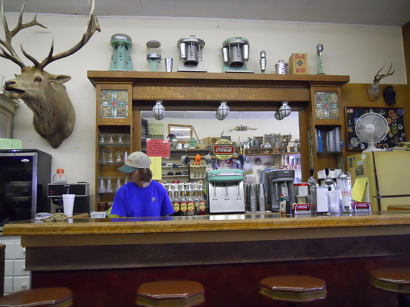
The History of the Chugwater Soda Fountain The Oldest Operating Soda fountain in Wyoming The Soda fountain is housed in one of the oldest buildings in Chugwater. The building was built in 1914, later, partially burned down, and was rebuilt in 1916. It has been a Doctor's office and a pharmacy. There was a small apartment in the back where the doctor and his family lived. The pharmacy drawers are still intact along one wall of the store. The soda fountain bar was built in England and installed in a business in Rock Creek WY. when the Railroad went through in 1927, the town moved to Tock River. The owner was not interested in moving his business, so he sold his equipment to the owner of the pharmacy in Chugwater. The bar was broken aprt into three pieces - the main bar, the top(including the mirror), and the bottom cabinets. It was then packed into wagons and transported over the mountains to be installed in this building. The mirror and glass are all original; you can stand in the back and see the curve in the mirror.1 The pharmacy and soda fountain co-existed for some time, but eventually one of the owners no longer had a pharmacy license and the store became a soda fountain only. Ownership has changed hands many times, with different people making various changes. The large elk overlooking the room is nicknamed "Wendall" for the man who shot him. He was shot near Jackson, WY in 1946 and has resided in the soda fountain since 1947. A town petition prevents Wendall from leaving, no matter who owns it. Over time, different owners have added components like the small package liquor store, "diner", and the Beer Garden in the summer. It remains one of few active soda fountains in the state that serves traditional, hand dipped ice cream shakes and malts. |
| Дата | |
| Источник | Chugwater Soda Fountain |
| Автор | Konrad Summers from Santa Clarita (Valencia) , California, USA |
| Местоположение камеры | | Это и другие изображения по их местоположению на OpenStreetMap |
|---|
Лицензирование
- Вы можете свободно:
- делиться произведением – копировать, распространять и передавать данное произведение
- создавать производные – переделывать данное произведение
- При соблюдении следующих условий:
- атрибуция – Вы должны указать авторство, предоставить ссылку на лицензию и указать, внёс ли автор какие-либо изменения. Это можно сделать любым разумным способом, но не создавая впечатление, что лицензиат поддерживает вас или использование вами данного произведения.
- распространение на тех же условиях – Если вы изменяете, преобразуете или создаёте иное произведение на основе данного, то обязаны использовать лицензию исходного произведения или лицензию, совместимую с исходной.
| Это изображение изначально опубликовано на Flickr участником проекта tkksummers по ссылке https://www.flickr.com/photos/12806074@N08/4712851275. Оно было досмотрено 14 июля 2015 роботом FlickreviewR, который подтвердил, что изображение лицензировано в соответствии с условиями cc-by-sa-2.0. |
История файла
Нажмите на дату/время, чтобы посмотреть файл, который был загружен в тот момент.
| Дата/время | Миниатюра | Размеры | Участник | Примечание | |
|---|---|---|---|---|---|
| текущий | 21:22, 14 июля 2015 | | 4000 × 3000 (2,66 Мб) | Tillman | Transferred from Flickr via Flickr2Commons |
Использование файла
Следующая страница использует этот файл:
Глобальное использование файла
Данный файл используется в следующих вики:
- Использование в ar.wikipedia.org
- Использование в azb.wikipedia.org
- Использование в ca.wikipedia.org
- Использование в ceb.wikipedia.org
- Использование в ce.wikipedia.org
- Использование в cy.wikipedia.org
- Использование в de.wikipedia.org
- Использование в en.wikipedia.org
- Использование в en.wikivoyage.org
- Использование в es.wikipedia.org
- Использование в eu.wikipedia.org
- Использование в fa.wikipedia.org
- Использование в fr.wikipedia.org
- Использование в ht.wikipedia.org
- Использование в it.wikipedia.org
- Использование в lld.wikipedia.org
- Использование в pl.wikipedia.org
- Использование в pt.wikipedia.org
- Использование в sr.wikipedia.org
- Использование в tt.wikipedia.org
- Использование в uk.wikipedia.org
- Использование в uz.wikipedia.org
- Использование в www.wikidata.org
- Использование в zh-min-nan.wikipedia.org