Файл:Haasis & Lubrecht American Union Railroad Map 1871 UTA.jpg

Исходный файл (2526 × 1824 пкс, размер файла: 3,31 МБ, MIME-тип: image/jpeg)
Этот файл находится на Викискладе. Сведения о нём показаны ниже.
Викисклад — централизованное хранилище для свободных файлов, используемых в проектах Викимедиа.
|
Краткое описание
| Название |
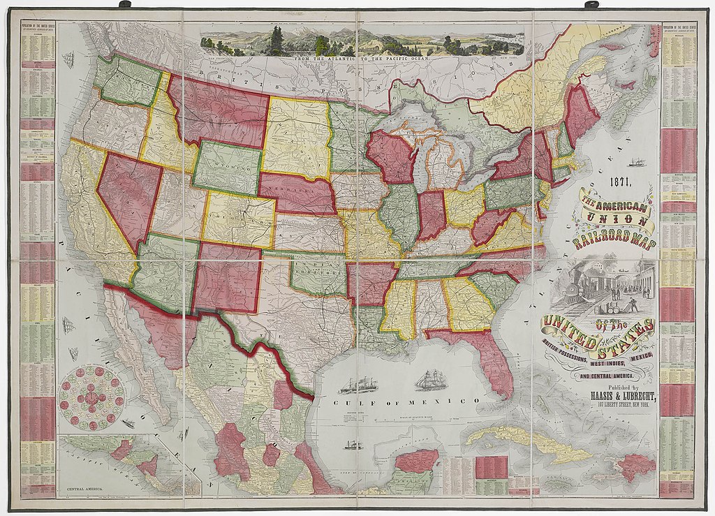
English: The American Union Railroad Map of the United States, British Possessions, West Indies, Mexico, and Central America |
||||||||||||||||||||||||||
| Описание |
English: By 1871, when the New York publishers Haasis & Lubrecht produced this large, bold, and colorful folding map, the first transcontinental railroad was already in operation, having been completed just two years earlier. (The Central Pacific Railroad, building east from Sacramento, and the Union Pacific, building west from Omaha, Nebraska, met at Promontory Summit, Utah, on May 10, 1869). Oddly, only the Central Pacific is labeled on the map, and there is no key or list of railroads; nevertheless, many of the first transcontinental railroad's actual stops are depicted along the solid line. The line of the Kansas Pacific Railway, running west from Kansas City is shown as completed to Denver, having arrived there in August 1870 where it linked up with the recently completed Denver Pacific Railway that linked the whole line with the Union Pacific at Cheyenne, Wyoming. A number of proposed railroads also appear on the map, shown by reticulated lines. These include the important Northern Pacific and Southern Pacific, to mention only a couple.
The Haasis & Lubrecht railroad map, issued in 1870, 1871, and 1872 editions, had a number of interesting features intended to attract purchasers. The stylish cartouche employs an exuberant tri-colored font for the title mixed with other fonts reminiscent of the attention-drawing broadsides advertising circuses, musical and theater performances in the Victorian or "Gilded Age" of boosterism. The image of an American-type 2-4-0 wood-burning locomotive arriving at, or departing from, an eastern, northern, or midwestern city or town, the vignettes of sail- and steamships, and the large landscape panorama at the top of the map adds to the map's attraction for buyers. Arguably, perhaps more practical is the inclusion at the lower left of the "Time and Distance Table between Washington and the Principal Places in North and Central America". This highlights a problem that confronted the railroads over vast distances. To run efficiently, the railroads had to establish a better control of time and soon proposed the system of "time zones" employed today. Finally, the pictorial panorama with the railroad running through it at the top of the map conveys a sense of the expanse of the nation and the optimistic sense that the new technology of the railroad or "machine in the garden" would succeed in uniting the two coasts and the country's differences after the terrible Civil War. |
||||||||||||||||||||||||||
| Дата | |||||||||||||||||||||||||||
| Источник | UTA Libraries Cartographic Connections: карта / текст | ||||||||||||||||||||||||||
| Создатель |
Haasis & Lubrecht |
||||||||||||||||||||||||||
| Дополнительная информация |
English: The University of Texas at Arlington Libraries Special Collections |
||||||||||||||||||||||||||
| Geotemporal data | |||||||||||||||||||||||||||
| Map location | США | ||||||||||||||||||||||||||
| Georeferencing | If inappropriate please set warp_status = skip to hide. | ||||||||||||||||||||||||||
| Bibliographic data | |||||||||||||||||||||||||||
| Место издания | Нью-Йорк | ||||||||||||||||||||||||||
| Издательство |
Haasis & Lubrecht |
||||||||||||||||||||||||||
| Archival data | |||||||||||||||||||||||||||
| Коллекция |
|
||||||||||||||||||||||||||
| Размеры | высота: 95 см; ширина: 129 см | ||||||||||||||||||||||||||
| Техника | хромолитография на бумаге | ||||||||||||||||||||||||||
| artwork-references | Tooley's Dictionary of Mapmakers, 2, стр. 241 | ||||||||||||||||||||||||||
Лицензирование

|
This file was provided to Wikimedia Commons by the University of Texas at Arlington Libraries as part of a cooperation project. The University of Texas at Arlington Libraries is part of the University of Texas at Arlington, a public research university located in Arlington, Texas.
|
Эта работа была опубликована до 1 января 1929 года анонимно или под псевдонимом в связи с неизвестным авторством. Она является общественным достоянием в Соединённых Штатах, а также в странах и территориях, где срок действия авторских прав на анонимные или опубликованные под псевдонимом работы составляет не более 95 лет со дня публикации.
|
История файла
Нажмите на дату/время, чтобы посмотреть файл, который был загружен в тот момент.
| Дата/время | Миниатюра | Размеры | Участник | Примечание | |
|---|---|---|---|---|---|
| текущий | 21:59, 25 марта 2022 | | 2526 × 1824 (3,31 МБ) | Michael Barera | == {{int:filedesc}} == {{Map |title = {{en|'''''The American Union Railroad Map of the United States, British Possessions, West Indies, Mexico, and Central America'''''}} |description = {{en|By 1871, when the New York publishers Haasis & Lubrecht produced this large, bold, and colorful folding map, the first transcontinental railroad was already in operation, having been completed just two years earlier. (The Central Pacific Railroad, building east from Sacramento, and the... |
Использование файла
Следующая страница использует этот файл:
Глобальное использование файла
Данный файл используется в следующих вики:
- Использование в en.wikipedia.org
- Использование в fr.wikipedia.org
- Использование в hu.wikipedia.org