Файл:Han Civilisation.png

Исходный файл (880 × 650 пкс, размер файла: 1 Мб, MIME-тип: image/png)
Этот файл находится на Викискладе. Сведения о нём показаны ниже.
Викисклад — централизованное хранилище для свободных файлов, используемых в проектах Викимедиа.
|

|
Это изображение неизвестного типа «historical map» желательно воссоздать или аккуратно преобразовать в векторный формат SVG. Это даёт несколько преимуществ, прочитать о которых подробнее вы можете на странице Commons:Media for cleanup. Если вам уже сейчас доступна векторная версия данного изображения, загрузите её, пожалуйста, а затем замените этот шаблон на следующий: {{Vector version available|Имя загруженного файла.svg}}.
|
|
| Описание |
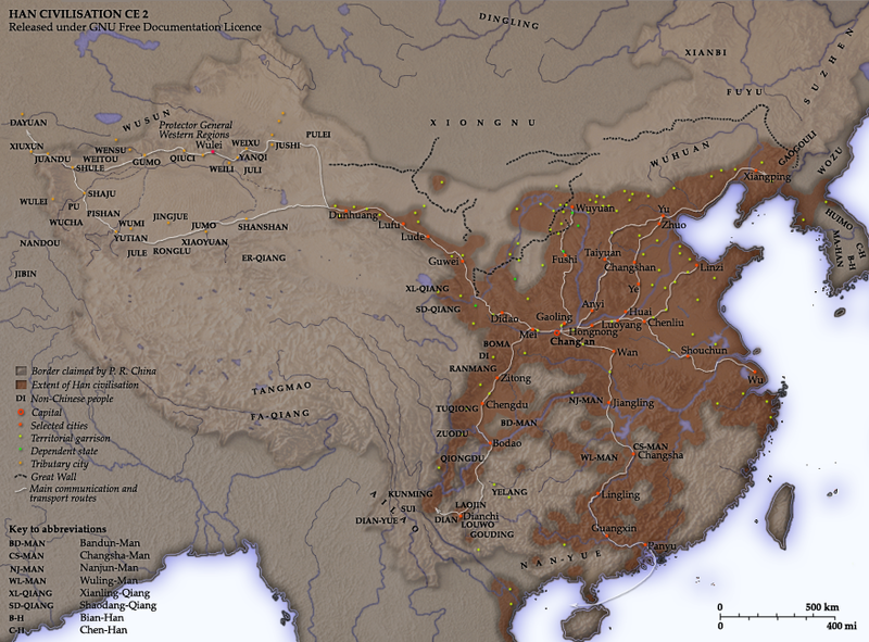
NotesCreated and copyright (2006) by Yeu Ninje. Released under the GNU FDL. This map shows the world as was known to en:Han Dynasty en:China in en:2 CE. The shaded areas show the extent of Han civilisation. I've based this on the existence of settlements under direct Han political authority or military control according to Tan Qixiang (ed.), Zhongguo lishi ditu (中国历史地图集; 1982). The international boundary shown is the border claimed by but never actually administered by the en:People's Republic of China. Compare the territories of the historical Han dynasty and the territories over which the modern Chinese state claims sovereignty. Territorial garrisonsThe headquarters of chief commandants (都尉) are shown in yellow. Chief commandants commanded territorial garrisons and were responsible for the supression of local armed threats and supervision of recruitment for military service. Note that these were concentrated on the frontiers, especially on the northern border region. When in the interior of the Han empire, they were often placed near en:iron or en:salt industries, or on important communication routes. Dependent states (屬國) are shown in green. These were usually mixed settlements of Chinese and Xiongnu or more commonly, en:Qiang, under Han administration. The Great WallDuring most of the Western Han period, the en:Great Wall served as a line of demarcation between Han and non-Chinese peoples, most notable of whom were the en:Xiongnu. The line of the Great Wall was extended by Emperor Wu along the en:Gansu corridor (the commanderies based at Dunhuang, Lufu, Lude and Guzang). This, along with walls north of the great loop of the en:Yellow River (beyond Wuyuan), provided the front line defences against the Xiongnu. A second line was maintained along the old Qin wall (the one that passes close to Fushi and Didao), which was important even into the en:1st century. Both the lines of the Great Wall and Yellow River are based on Tan Qixiang (ed.), Zhongguo lishi ditu (中国历史地图集; 1982). Note that the Yellow River is considerably to the north of its present flow. Routes of communicationThe broad outline of communication and transport routes from the capital en:Chang'an is marked in white. These were based on en:Qin Dynasty imperial highways, Han roads (such as the Chang'an-Anyi-Taiyuan-Yu road) and navigable riverways (such as the Chenliu and Shouchun route). The long road extending west from Chang'an to the "en:Western Regions" is often known as the en:Silk Road. These are based in part on the reconstruction of early Chinese roads and waterways by en:Joseph Needham in Science and Civilisation, Vol. IV, (1954), and the additions of en:Rafe de Crespigny in Generals of the South (1992). The northern and southern routes of the Silk Road in the Western Regions is based on Map 16 in Cambridge History of China, vol. 1, (1986). The Western RegionsFrom the end of the en:2nd century BC, Han China fought with the Xiongnu over control of the Western Regions. By the time that they established the office of Protector General of the Western Regions (at Wulei) in en:60 BC or en:59 BC, the entire region was dominated by the Chinese. Tributary city-states, in light orange, sent periodic tribute to Chang'an and were rewarded by the Han court. TransliterationNames of non-Chinese peoples and states have been purposely left with their Chinese names (e.g. Dayuan instead of en:Fergana; Gaogouli instead of en:Goguryeo) to reflect the fact that our knowledge of participants in the Han world order comes almost exclusively from Chinese sources. Chinese names are transliterated by en:pinyin (e.g. Dayuan instead of Ta-yuan). Transliteration of non-Chinese peopes and states follows the pronunciation guides given in the Hou Han shu. They often diverge from the Mandarin pronunciations which are now standard: 婼羌 Er-Qiang; 鄯善 Shanshan; 且末 Jumo; 小宛 Xiao-Yuan; 精絕 Jingjue; 戎盧 Ronglu; 扜彌 Wumi; 渠勒 Jule; 于闐 Yutian; 皮山 Pishan; 烏秅 Wucha; 西夜 Xiye (Xiyi); 蒲 Pu; 依耐 Yinai; 無雷 Wulei; 難兜 Nandou; 罽賓 Jibin; 烏弋山離 Wuyishanli; 安息 Anxi; 大月氏 Da-Yuezhi; 康居 Kangju; 大宛 Da-Yuan; 桃槐 Taohui; 休循 Xiuxun; 捐毒 Juandu; 莎車 Shaju; 疏勒 Shule; 尉頭 Weitou; 龜茲 Qiuci; 姑墨 Gumo; 焉耆 Yanqi. Related images
|
||||||||
| Дата | |||||||||
| Источник | Own work compiled from and based on the sources stated above | ||||||||
| Автор | User Yeu Ninje on en.wikipedia | ||||||||
| Права (Повторное использование этого файла) |
Yeu Ninje из английской Википедии, владелец авторских прав на это произведение, добровольно публикует его на условиях следующей лицензии:
|
||||||||
| Другие версии |
Производные работы от этого файла: Han Civilisation bright large.jpg Originally from en.wikipedia; description page is (was) here * 21:06, 14 June 2006 [[:en:User:Yeu Ninje|Yeu Ninje]] 880×650 (1,051,992 bytes) <span class="comment">(Border of P. R. China --> Border claimed by P. R. China.)</span> * 12:44, 1 March 2006 [[:en:User:Yeu Ninje|Yeu Ninje]] 880×650 (1,054,864 bytes) <span class="comment">(more small changes.)</span> * 01:07, 26 February 2006 [[:en:User:Yeu Ninje|Yeu Ninje]] 880×650 (1,052,476 bytes) * 21:53, 25 February 2006 [[:en:User:Yeu Ninje|Yeu Ninje]] 880×650 (919,134 bytes) <span class="comment">(Created and copyright (2006) by [[:en:Yeu Ninje]]. Released under the [[:en:GNU FDL]].)</span> |


(Uploaded using CommonsHelper or PushForCommons)
История файла
Нажмите на дату/время, чтобы посмотреть файл, который был загружен в тот момент.
| Дата/время | Миниатюра | Размеры | Участник | Примечание | |
|---|---|---|---|---|---|
| текущий | 08:56, 2 ноября 2006 | | 880 × 650 (1 Мб) | Shizhao | {{Information| |Description= __NOTOC__ == Notes == Created and copyright (2006) by Yeu Ninje. Released under the GNU FDL. This map shows the world as was known to en:Han Dynasty [[:en:Ch |
Использование файла
Глобальное использование файла
Данный файл используется в следующих вики:
- Использование в an.wikipedia.org
- Использование в ar.wikipedia.org
- Использование в azb.wikipedia.org
- Использование в beta.wikiversity.org
- Использование в en.wikipedia.org
- Xiongnu
- User talk:Yeu Ninje
- History of Yunnan
- User:Yeu Ninje/Maps
- Wikipedia:Featured picture candidates/delist/2006
- Wikipedia:Picture of the day/June 2006
- User talk:La goutte de pluie/archive 5
- Wikipedia:Featured picture candidates/Han foreign relations 2 CE
- Wikipedia:Wikipedia Signpost/2006-03-13/Features and admins
- Wikipedia:Featured picture candidates/March-2006
- Wikipedia:Picture of the day/June 13, 2006
- Wikipedia:POTD/June 13, 2006
- Wikipedia:POTD column/June 13, 2006
- Wikipedia:POTD row/June 13, 2006
- Portal:Geography/Featured picture/2006, week 25
- Wikipedia:Featured picture candidates/Han Civilisation.png
- Portal:China/Selected article and pictures
- Portal:Maps/Selected picture
- Portal:China/Selected picture/2006
- Portal:China/Selected picture/2006/December
- Portal:Geography/Featured picture archive/2006
- User talk:Yu Ninjie~enwiki/Archive 2006
- Portal:Maps/Selected picture/19
- Chao Cuo
- Wikipedia:Featured picture candidates/delist/2009
- History of the Han dynasty
- User talk:Jimbo Wales/Archive 10
- Wikipedia:Featured picture candidates/delist/File:Han Civilisation.png
- Wikipedia:Wikipedia Signpost/2006-03-13/SPV
- User:JPxG/SP 2006-2010
- Wikipedia:Wikipedia Signpost/Single/2006-03-13
- Использование в en.wiktionary.org
- Использование в fr.wikipedia.org
- Использование в he.wikipedia.org
- Использование в hi.wikipedia.org
- Использование в id.wikipedia.org
- Использование в it.wikipedia.org
- Использование в kk.wikipedia.org
- Использование в la.wikipedia.org
- Использование в lfn.wikipedia.org
Просмотреть глобальное использование этого файла.