Файл:ISS-30 Lake Fitri, Chad.jpg
Размер этого предпросмотра: 800 × 531 пкс. Другие разрешения: 320 × 213 пкс | 640 × 425 пкс | 1024 × 680 пкс | 1280 × 850 пкс | 2560 × 1700 пкс | 4288 × 2848 пкс.
Исходный файл (4288 × 2848 пкс, размер файла: 6,37 Мб, MIME-тип: image/jpeg)
Этот файл находится на Викискладе. Сведения о нём показаны ниже.
Викисклад — централизованное хранилище для свободных файлов, используемых в проектах Викимедиа.
|
Краткое описание
| Описание |
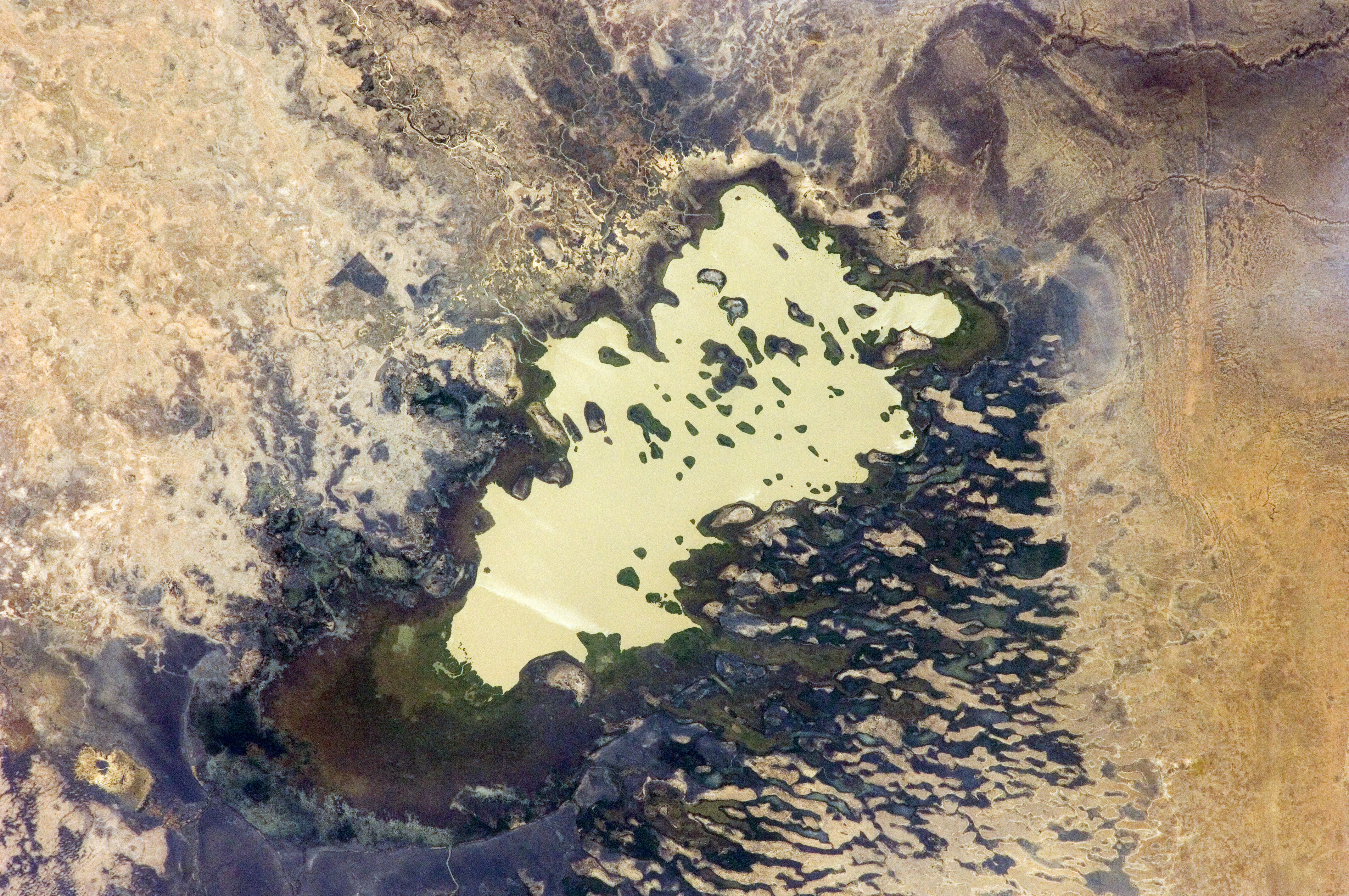
English: Lake Fitri, Chad is featured in this image photographed by an Expedition 30 crew member on the International Space Station.
|
| Дата | |
| Источник | http://spaceflight.nasa.gov/gallery/images/station/crew-30/html/iss030e059398.html |
| Автор | NASA |
Это изображение или видеозапись внесены в каталог Космического центра имени Джонсона НАСА под идентификатором (Photo ID): ISS030-E-059398. Этот шаблон не указывает на правовой статус данной работы. По-прежнему необходим нормальный шаблон лицензий. См. Commons:Лицензирование. Другие языки:
|
Лицензирование
This file is in the public domain in the United States because it was created by the Image Science & Analysis Laboratory, of the NASA Johnson Space Center. NASA copyright policy states that "NASA material is not protected by copyright unless noted". (NASA media use guidelines or Conditions of Use of Astronaut Photographs).
Photo source: ISS030-E-59398.
|
История файла
Нажмите на дату/время, чтобы посмотреть файл, который был загружен в тот момент.
| Дата/время | Миниатюра | Размеры | Участник | Примечание | |
|---|---|---|---|---|---|
| текущий | 20:00, 20 апреля 2016 | | 4288 × 2848 (6,37 Мб) | Ras67 | new rendered in high quality from NASA's raw image data |
| 12:46, 4 июня 2012 |  | 4288 × 2848 (2,03 Мб) | Ras67 | levels | |
| 17:59, 21 февраля 2012 |  | 4288 × 2848 (1,76 Мб) | Ras67 | {{Information |Description ={{en|1=Lake Fitri, Chad is featured in this image photographed by an Expedition 30 crew member on the International Space Station. Lake Fitri is an endorheic, or terminal lake in a desert basin in the southern Sahara Desert. |
Использование файла
Следующая страница использует этот файл:
Глобальное использование файла
Данный файл используется в следующих вики:
- Использование в ar.wikipedia.org
- Использование в arz.wikipedia.org
- Использование в be.wikipedia.org
- Использование в cv.wikipedia.org
- Использование в de.wikipedia.org
- Использование в el.wikipedia.org
- Использование в en.wikipedia.org
- Использование в es.wikipedia.org
- Использование в fr.wikipedia.org
- Использование в id.wikipedia.org
- Использование в it.wikipedia.org
- Использование в ka.wikipedia.org
- Использование в lt.wikipedia.org
- Использование в my.wikipedia.org
- Использование в nl.wikipedia.org
- Использование в pl.wikipedia.org
- Использование в vi.wikipedia.org
- Использование в www.wikidata.org