Файл:Ince Castle - geograph.org.uk - 344828 cropped.jpg
Нет версии с бо́льшим разрешением.
Ince_Castle_-_geograph.org.uk_-_344828_cropped.jpg (244 × 148 пкс, размер файла: 17 Кб, MIME-тип: image/jpeg)
Этот файл находится на Викискладе. Сведения о нём показаны ниже.
Викисклад — централизованное хранилище для свободных файлов, используемых в проектах Викимедиа.
|
Краткое описание
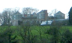
| Описание |
English: Ince Castle, 3 miles (5 km) from Saltash, Cornwall, England. It was built in 1642 at the start of the Civil War and was captured in 1646. It consists of 4 three storey towers with walls 4 foot thick. By the 1850s it was used as a farm and was allowed to decay but it was restored in the early 20th century. It burnt down in 1986 (apparently by grandmother being a bit irresponsible with a candle) – but it has now been rebuilt. In 1649, John Killigrew inherited Ince Castle from an uncle. He married four wives and installed them separately into each of the four towers giving them a story that the fields were plagued with mice – which kept them inside. For some time, each of the four ladies lived happily in ignorance of the other three, until a thicko servant delivered a letter to the wrong wife, and all was revealed! John Killigrew was sentenced to sixteen years, four years for each count of bigamy. John pointed out to the judge that, as his first marriage was not bigamous, he should serve only twelve years! Good lad. It is now the home of Lord and Lady Boyd who probably wouldn't like to see me making footprints in their ever so posh mud. |
| Дата | |
| Источник |
Этот файл является производной работой от: Ince Castle - geograph.org.uk - 344828.jpg |
| Автор | Bill Booth |
| Другие версии |

| Местоположение камеры | | Это и другие изображения по их местоположению на OpenStreetMap |
|---|
_region:GB-GBN_heading:225.00&language=ru)
| Местоположение объекта | | Это и другие изображения по их местоположению на OpenStreetMap |
|---|
_region:GB-GBN_heading:225.00&language=ru)
Этот файл доступен по лицензии Creative Commons Attribution-Share Alike 2.0 Generic
Атрибуция: Bill Booth
- Вы можете свободно:
- делиться произведением – копировать, распространять и передавать данное произведение
- создавать производные – переделывать данное произведение
- При соблюдении следующих условий:
- атрибуция – Вы должны указать авторство, предоставить ссылку на лицензию и указать, внёс ли автор какие-либо изменения. Это можно сделать любым разумным способом, но не создавая впечатление, что лицензиат поддерживает вас или использование вами данного произведения.
- распространение на тех же условиях – Если вы изменяете, преобразуете или создаёте иное произведение на основе данного, то обязаны использовать лицензию исходного произведения или лицензию, совместимую с исходной.
Исходный журнал загрузок
This image is a derivative work of the following images:
- File:Ince Castle - geograph.org.uk - 344828.jpg licensed with Cc-by-sa-2.0, Geograph
- 2011-01-02T17:18:58Z GeographBot 640x435 (64700 Bytes) == {{int:filedesc}} == {{Information |description={{en|1=Ince Castle This is Ince Castle which was built in 1642 at the start of the Civil War and was captured in 1646. It consists of 4 three storey towers with walls 4 foot t
Uploaded with derivativeFX
История файла
Нажмите на дату/время, чтобы посмотреть файл, который был загружен в тот момент.
| Дата/время | Миниатюра | Размеры | Участник | Примечание | |
|---|---|---|---|---|---|
| текущий | 17:15, 12 мая 2011 | | 244 × 148 (17 Кб) | Paravane | {{Information |Description={{en|1=Ince Castle This is Ince Castle which was built in 1642 at the start of the Civil War and was captured in 1646. It consists of 4 three storey towers with walls 4 foot thick. By the 1850s it was used as a farm and was allo |
Использование файла
Следующая страница использует этот файл:
Глобальное использование файла
Данный файл используется в следующих вики:
- Использование в da.wikipedia.org
- Использование в de.wikipedia.org
- Использование в en.wikipedia.org
- Использование в en.wikibooks.org
- Использование в pt.wikipedia.org