Файл:Island of Ireland location map Kildare.svg

Размер этого PNG-превью для исходного SVG-файла: 481 × 599 пкс. Другие разрешения: 192 × 240 пкс | 385 × 480 пкс | 616 × 768 пкс | 822 × 1024 пкс | 1643 × 2048 пкс | 1450 × 1807 пкс.
Исходный файл (SVG-файл, номинально 1450 × 1807 пкс, размер файла: 642 КБ)
Этот файл находится на Викискладе. Сведения о нём показаны ниже.
Викисклад — централизованное хранилище для свободных файлов, используемых в проектах Викимедиа.
|
| Описание |
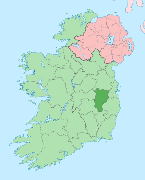
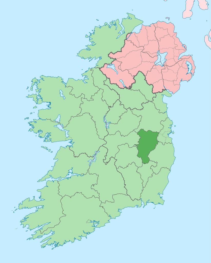
English: The island of Ireland, showing international border between Ireland and Northern Ireland, traditional provinces, traditional counties, and local authority areas in Ireland and Northern Ireland. |
| Дата | (UTC) |
| Источник | |
| Автор |
|
| Это отретушированное изображение, что означает, что первоначальной версия изображения была изменена цифровым способом. Изменения: Coloured in regions with county of article highlighted. Оригинал доступен по ссылке: Island of Ireland location map.svg:
|
Я, владелец авторских прав на это произведение, добровольно публикую его на условиях следующей лицензии:
Этот файл доступен по лицензии Creative Commons Attribution-Share Alike 3.0 Unported.
- Вы можете свободно:
- делиться произведением – копировать, распространять и передавать данное произведение
- создавать производные – переделывать данное произведение
- При соблюдении следующих условий:
- атрибуция – Вы должны указать авторство, предоставить ссылку на лицензию и указать, внёс ли автор какие-либо изменения. Это можно сделать любым разумным способом, но не создавая впечатление, что лицензиат поддерживает вас или использование вами данного произведения.
- распространение на тех же условиях – Если вы изменяете, преобразуете или создаёте иное произведение на основе данного, то обязаны использовать лицензию исходного произведения или лицензию, совместимую с исходной.
Исходный журнал загрузок
This image is a derivative work of the following images:
- File:Island_of_Ireland_location_map.svg licensed with Cc-by-sa-3.0
- 2010-03-06T20:43:33Z Rannpháirtí anaithnid 1450x1807 (679207 Bytes) Fix incorrectly coloured isands.
- 2010-03-03T22:19:29Z Rannpháirtí anaithnid 1450x1807 (679744 Bytes) {{Information |Description={{de|Positionskarte von [[:de:Irland|Irland]]}} Quadratische Plattkarte, N-S-Streckung 170 %. Geographische Begrenzung der Karte: * N: 55.6° N * S: 51.2° N * W: 11.0° W * O: 5.0° W {{en|Location
Uploaded with derivativeFX
История файла
Нажмите на дату/время, чтобы посмотреть файл, который был загружен в тот момент.
| Дата/время | Миниатюра | Размеры | Участник | Примечание | |
|---|---|---|---|---|---|
| текущий | 09:12, 3 июля 2020 | | 1450 × 1807 (642 КБ) | Chipmunkdavis | Per the Local Government Reform Act 2014, joining both Tipperarys and both Waterfords (and removing Limerick City code). Colouring in islands, cleaning up and grouping code to remove stray objects and show Galway and Lough Ree. |
| 00:48, 19 июля 2010 |  | 1450 × 1807 (815 КБ) | Mabuska | {{Information |Description={{en|The island of Ireland, showing international border between Northern Ireland and Republic of Ireland, traditional provinces, traditional counties, and local authority areas in the Republic of Ireland and Northern Ireland.}} |
Использование файла
Следующая страница использует этот файл:
Глобальное использование файла
Данный файл используется в следующих вики:
- Использование в ar.wikipedia.org
- Использование в ast.wikipedia.org
- Использование в be.wikipedia.org
- Использование в bg.wikipedia.org
- Использование в ca.wikipedia.org
- Comtat de Kildare
- Naas
- Maynooth
- Leixlip
- Plantilla:Comtat Kildare
- Athy
- Newbridge (Kildare)
- Kildare
- Curragh
- Turó d'Allen
- Monasterevin
- Castledermot
- Calverstown
- Allen (Kildare)
- Kilcullen
- Ballymore Eustace
- Rathangan (Kildare)
- Prosperous
- Allenwood
- Caragh
- Clane
- Kill (Kildare)
- Kilcock
- Baile Eoin
- Baile an Mhuilinn (Kildare)
- Использование в ceb.wikipedia.org
- Использование в cs.wikipedia.org
- Использование в da.wikipedia.org
- Использование в en.wikipedia.org
Просмотреть глобальное использование этого файла.