Файл:Kangshung-06.PNG

Размер этого предпросмотра: 800 × 526 пкс. Другие разрешения: 320 × 210 пкс | 640 × 421 пкс | 1157 × 761 пкс.
Исходный файл (1157 × 761 пкс, размер файла: 1,95 МБ, MIME-тип: image/png)
Этот файл находится на Викискладе. Сведения о нём показаны ниже.
Викисклад — централизованное хранилище для свободных файлов, используемых в проектах Викимедиа.
|
Краткое описание
| Описание |
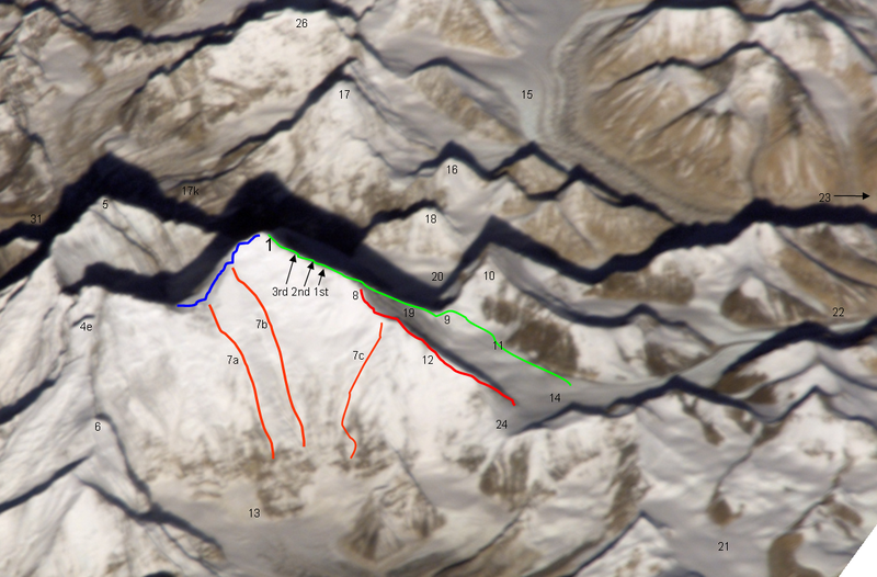
Deutsch: Ost- (Kangshung-) Wand des Mount Everest mit Umgebung |
|
| Дата | 12 ноября 2008 (дата первоначальной загрузки файла на вики) | |
| Источник | Перенесено с de.wikipedia на Викисклад участником Rupert Pupkin при помощи CommonsHelper. | |
| Автор |
Фотография: NASA |
|
| Другие версии |
|


Notes
| green line | Normal route, mainly the Mallory route 1924, via high camps on 7700 and 8300 m, via "yellow band", exit cracks & upper NE ridge w. "Second Step") |
| red line / no.12 | lower and middle NE ridge |
| blue line | upper SE ridge (part of the «Hillary route» 1953 etc. coming from Western Qwm (in the shadow behind Mt. Everest) meeting point with the orange route 7a is the south col meeting point with the orange route 7b is the balcony |
| orange line 7a | 1988 US and GB ascent (Stephen Vernables et al.) |
| orange line 7b | 1982 US ascent (Carlos Buhler, Kim Momb et al.) |
| orange line 7c | “Phantasy Ridge” (acc. to a speech of George Mallory), no successful ascent until 2008, tried by Cathy O’Dowd and Ian Woodall; they came half way to NE ridge & Pinnacles |
| 1 | summit of Mount Everest 8848m |
| 3rd 2nd 1st | steps on the Upper NE ridge 8700m, 8605m and 8530m |
| 4e | Lhotse Shar |
| 5 | Nuptse |
| 6 | “Peak 38” |
| 13 | Kangshung Glacier |
| 8 | “Three Pinnacles” where Joe Tasker and Peter Boardman died 1982 (2nd pinnacle) |
| 9 | North Col on 7050m |
| 14 | East Rongbuk Glacier |
| 10 | Changtse (northern summit) |
| 11 | ABC Advanced Base Camp (North) on the upper East Rongbuk Glacier in front of the ice wall to north col |
| 15 | West Rongbuk Glacier (coming from the Cho Oyu and Gyachung Kang flanks) |
| 16 | Lingtren |
| 17 | Pumori |
| 17k | Kala Patthar, “Everest Trekking View Point” from the south side |
| 18 | Khumbutse (summit west of Lho La which is the connection on 6006m of the glacier systems of Rongbu and Khumbu and is also the tibetian-nepalian borderline / like SE ridge & W ridge. Lho La is "foot point" of the Everest W ridge.) |
| 19 | north ridge // below of fig. 19 the Zakharov Couloir offering a tough ascent to NE ridge without going via north col |
| 20 | Main Rongbuk Glacier |
| 21 | upper Kharta Glacier (Mallory 1921, where discovered the access to North Col) |
| 22 | Camp II of the early british expeditions 1922+1924 |
| 23 | to the Base camp on foot of the Main Rongbuk Glacier and to Rongbuk Gompa (Monastery) |
| 24 | Rapiu La (connection from Eastern Rongbuk Glacier System to Kangshung Glacier System) |
Лицензирование
Original photograph:
| Этот файл находится в общественном достоянии (англ. public domain), так как он был создан NASA (Национальным управлением по аэронавтике и исследованию космического пространства). Политика авторского права NASA гласит, что «Материал NASA не защищается авторским правом, если не указано иное». (См. Template:PD-USGov, страницу политики авторского права NASA или политику использования изображений JPL.) |
Lines and points:
Kassander der Minoer из немецкий Википедия, владелец авторских прав на это произведение, добровольно публикует его на условиях следующей лицензии:

|
Разрешается копировать, распространять и/или изменять этот документ в соответствии с условиями GNU Free Documentation License версии 1.2 или более поздней, опубликованной Фондом свободного программного обеспечения, без неизменяемых разделов, без текстов, помещаемых на первой и последней обложке. Копия лицензии включена в раздел, озаглавленный GNU Free Documentation License. |
| Этот файл доступен по лицензии Creative Commons Attribution-Share Alike 3.0 Unported. | ||
| Атрибуция: Kassander der Minoer из немецкий Википедия | ||
| ||
| Этот признак лицензирования был добавлен к этому файлу как часть обновления лицензии GFDL. |
Исходный журнал загрузок
Первоначальная страница описания находилась здесь. Все нижеперечисленные имена участников относятся к de.wikipedia.
- 2008-11-12 20:39 Kassander der Minoer 1157×761× (2046200 bytes) {{Information |Beschreibung = Ost- (Kangshung-) Wand des Mount Everest mit Umgebung |Quelle = NASA & eigene Arbeit (Linien und Punkte markiert) |Urheber = NASA |Datum = 12.11.2008 |Genehmigung = US-Gov-GFDL |Andere Versionen = |Anmerkungen = }}
История файла
Нажмите на дату/время, чтобы посмотреть файл, который был загружен в тот момент.
| Дата/время | Миниатюра | Размеры | Участник | Примечание | |
|---|---|---|---|---|---|
| текущий | 21:59, 26 ноября 2008 | | 1157 × 761 (1,95 МБ) | File Upload Bot (Magnus Manske) | {{BotMoveToCommons|de.wikipedia}} {{Information |Description={{de|Ost- (Kangshung-) Wand des Mount Everest mit Umgebung}} |Source=Transferred from [http://de.wikipedia.org de.wikipedia]; transferred to Commons by User:Rupert Pupkin using [http://tool |
Использование файла
Следующие 3 страницы используют этот файл:
Глобальное использование файла
Данный файл используется в следующих вики:
- Использование в az.wikipedia.org
- Использование в bs.wikipedia.org
- Использование в de.wikipedia.org
- Использование в en.wikipedia.org
- Использование в es.wikipedia.org
- Использование в fr.wikipedia.org
- Использование в ro.wikipedia.org
- Использование в uk.wikipedia.org
- Использование в www.wikidata.org
- Использование в zh.wikipedia.org