Файл:Laguna de Términos.jpeg

Исходный файл (8797 × 5865 пкс, размер файла: 6,89 МБ, MIME-тип: image/jpeg)
Этот файл находится на Викискладе. Сведения о нём показаны ниже.
Викисклад — централизованное хранилище для свободных файлов, используемых в проектах Викимедиа.
|
Краткое описание
| Описание |
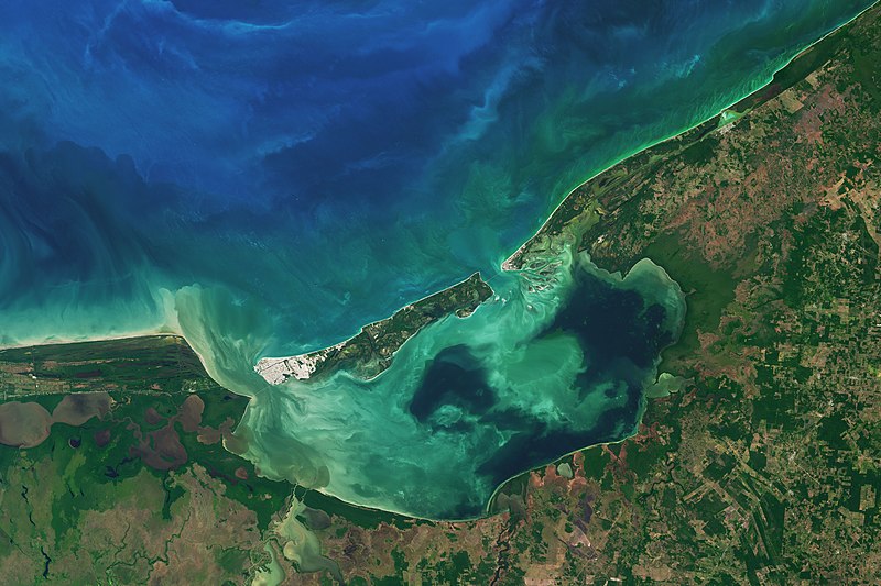
Along the coast of southeast Mexico, in the state of Campeche, wetlands and rivers give way to a shallow, swirling body of water. At 2500 square kilometers, Laguna de Términos is Mexico’s largest coastal lagoon. By definition, coastal lagoons maintain a connection to the sea through a restricted inlet. At Laguna de Términos, the flow of water between the lagoon and the Campeche Sound is impeded by Isla del Carmen, a 2.5-kilometer-wide barrier island. This arrangement means this lagoon has two inlets (or outlets): Sea water generally flows into the lagoon around the east of the island, and out past the western end. Campeche and its lagoon receive a healthy input of fresh water from a huge system of rivers flowing from the nearby states of Tabasco, Chiapas, and Guatemala. The flow varies depending on the season. When the Operational Land Imager (OLI) on the Landsat 8 satellite captured this image on January 20, 2017, the region was in the dry season, which runs from October through February. Four major river systems drain the watershed and feed the lagoon from the south and southwest, the largest of which is the Usumacinta River. Even in the dry season, these areas of the lagoon are fresher than other parts and more turbid—visible in this image as colorful swirls near the shore. Winds and tides also can stir up lagoon waters. Life is abundant here. Oyster beds thrive at the mouths of the major rivers. Beds of seagrass take hold in the saltier, calmer areas, particularly off of Isla del Carmen. And ringing much of the lagoon are uninterrupted patches of mangrove wetlands. The detailed image shows one such area on the eastern side of the lagoon. The mangroves and lagoon serve as a nursery for fish and shellfish, such as shrimp, which in turn support productive commercial fisheries in Campeche Sound. |
| Дата | |
| Источник | https://earthobservatory.nasa.gov/images/90893/laguna-de-terminos |
| Автор | NASA Earth Observatory images by Joshua Stevens, using Landsat data from the U.S. Geological Survey. Story by Kathryn Hansen. |
Лицензирование
| Этот файл находится в общественном достоянии (англ. public domain), так как он был создан NASA (Национальным управлением по аэронавтике и исследованию космического пространства). Политика авторского права NASA гласит, что «Материал NASA не защищается авторским правом, если не указано иное». (См. Template:PD-USGov, страницу политики авторского права NASA или политику использования изображений JPL.) | ||
 |
Предупреждения:
|
История файла
Нажмите на дату/время, чтобы посмотреть файл, который был загружен в тот момент.
| Дата/время | Миниатюра | Размеры | Участник | Примечание | |
|---|---|---|---|---|---|
| текущий | 04:05, 12 марта 2021 | | 8797 × 5865 (6,89 МБ) | StellarHalo | {{Information |Description=Along the coast of southeast Mexico, in the state of Campeche, wetlands and rivers give way to a shallow, swirling body of water. At 2500 square kilometers, Laguna de Términos is Mexico’s largest coastal lagoon. By definition, coastal lagoons maintain a connection to the sea through a restricted inlet. At Laguna de Términos, the flow of water between the lagoon and the Campeche Sound is impeded by Isla del Carmen, a 2.5-kilometer-wide barrier island. This arrangeme... |
Использование файла
Следующая страница использует этот файл:
Глобальное использование файла
Данный файл используется в следующих вики:
- Использование в en.wikipedia.org
- Использование в es.wikipedia.org
- Использование в ja.wikipedia.org
- Использование в www.wikidata.org
- Использование в zh.wikipedia.org