Файл:Largest counties of the United States by population as of the 2020 United States census.svg

Размер этого PNG-превью для исходного SVG-файла: 512 × 324 пкс. Другие разрешения: 320 × 203 пкс | 640 × 405 пкс | 1024 × 648 пкс | 1280 × 810 пкс | 2560 × 1620 пкс.
Исходный файл (SVG-файл, номинально 512 × 324 пкс, размер файла: 867 КБ)
Этот файл находится на Викискладе. Сведения о нём показаны ниже.
Викисклад — централизованное хранилище для свободных файлов, используемых в проектах Викимедиа.
|
Краткое описание
| Описание |
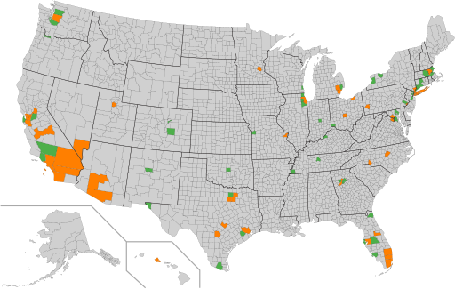
English: Counties with over 1 million inhabitants
Counties with under 1 million inhabitants
A map of the counties of the United States. The 100 most populous counties are highlighted, with those counties having more than one million residents in orange, and those counties having fewer than one million residents in green, as of the April 1, 2020 United States census. |
| Дата | |
| Источник | Собственная работа |
| Автор | Elli |
| Другие версии | Map derived from File:Largest counties of the United States by population as of the 2010 United States census.svg |
Лицензирование
| This map is ineligible for copyright and therefore in the public domain, because it consists entirely of information that is common property and contains no original authorship. For more information, see Commons:Threshold of originality § Maps.
|
История файла
Нажмите на дату/время, чтобы посмотреть файл, который был загружен в тот момент.
| Дата/время | Миниатюра | Размеры | Участник | Примечание | |
|---|---|---|---|---|---|
| текущий | 06:40, 24 декабря 2021 | | 512 × 324 (867 КБ) | Elli | Uploaded own work with UploadWizard |
Использование файла
Следующая страница использует этот файл:
Глобальное использование файла
Данный файл используется в следующих вики:
- Использование в cs.wikipedia.org
- Использование в en.wikipedia.org
- Использование в zh.wikipedia.org