Файл:Minustah.png
Minustah.png (603 × 449 пкс, размер файла: 181 КБ, MIME-тип: image/png)
Этот файл находится на Викискладе. Сведения о нём показаны ниже.
Викисклад — централизованное хранилище для свободных файлов, используемых в проектах Викимедиа.
|
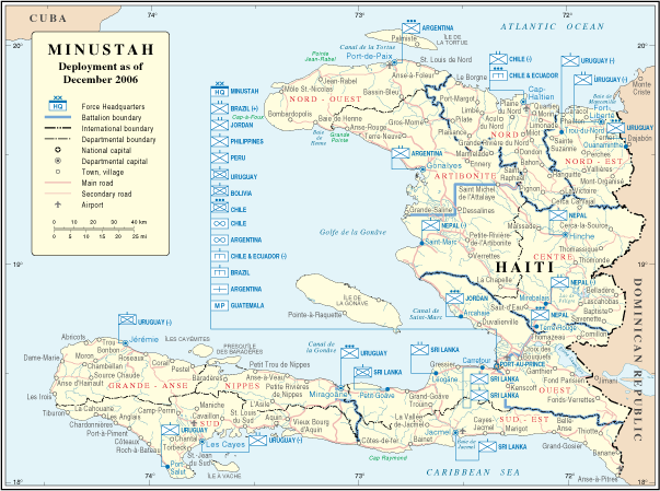
| Описание | Map of Haiti | |||
| Дата | ||||
| Источник | http://www.un.org/Depts/Cartographic/map/dpko/minustah.pdf | |||
| Автор | Department of Peacekeeping Operations Cartographic Section | |||
| Права (Повторное использование этого файла) |
|

История файла
Нажмите на дату/время, чтобы посмотреть файл, который был загружен в тот момент.
| Дата/время | Миниатюра | Размеры | Участник | Примечание | |
|---|---|---|---|---|---|
| текущий | 02:01, 23 октября 2007 | | 603 × 449 (181 КБ) | Jeroen | Bottom line is allowed according permissions by the UN: "UN maps are open source material and you can use them in your work or for making your own map. We request however that you '''delete the UN name and reference number upon any modification''' to the |
| 23:17, 22 января 2007 |  | 609 × 466 (181 КБ) | Cro-Cop2 | {{Information| |Description=Map of Haiti |Source=http://www.un.org/Depts/Cartographic/map/dpko/minustah.pdf |Date=December, 2006 |Author=Department of Peacekeeping Operations Cartographic Section |Permission={{UN map}} }} |
Использование файла
Следующая страница использует этот файл:
Глобальное использование файла
Данный файл используется в следующих вики:
- Использование в bg.wikipedia.org
- Использование в ca.wikipedia.org
- Использование в ckb.wikipedia.org
- Использование в de.wikipedia.org
- Использование в en.wikipedia.org
- Использование в en.wikinews.org
- Использование в es.wikipedia.org
- Использование в fa.wikipedia.org
- Использование в fr.wikipedia.org
- Использование в ht.wikipedia.org
- Использование в id.wikipedia.org
- Использование в mzn.wikipedia.org
- Использование в nl.wikipedia.org
- Использование в www.wikidata.org