Файл:NorthNatalWarTheatre, colour, crop.png
Исходный файл (730 × 1006 пкс, размер файла: 90 Кб, MIME-тип: image/png)
Этот файл находится на Викискладе. Сведения о нём показаны ниже.
Викисклад — централизованное хранилище для свободных файлов, используемых в проектах Викимедиа.
|
Краткое описание
| Описание |
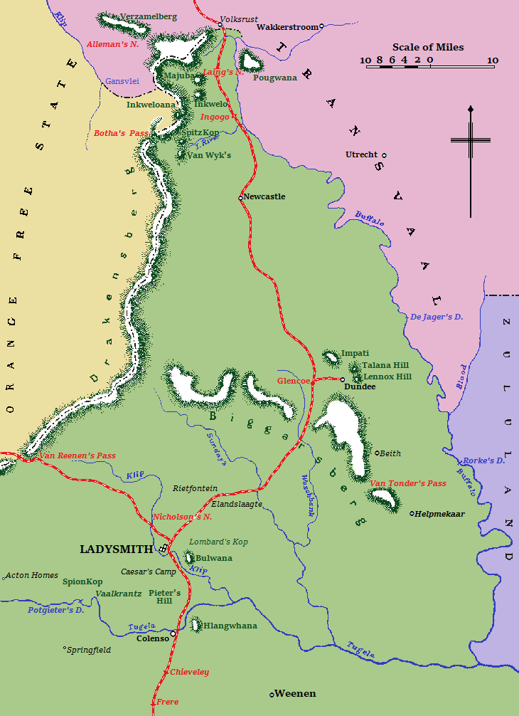
English: Map of the North Natal war theatre during the Second Anglo-Boer War.
Colony of Natal
Hills and mountains
Orange Free State
Transvaal (or South African Republic)
Zululand
|
| Дата | |
| Источник | Анонимный автор (1910) A Handbook of the Boer War - With General Map of South Africa and 18 Sketch Maps and Plans, London & Aldershot: Gale & Polden Ltd |
| Автор | Anonymous - marketed by Sutton, Praed & Co (cartographer) |
| Другие версии |
  |
| Местоположение объекта | | Это и другие изображения по их местоположению на OpenStreetMap |
|---|
Лицензирование
Этот медиафайл находится в общественном достоянии (англ. public domain) в Соединённых Штатах Америки. Это относится к опубликованным в США работам, авторское право на которые истекло, так как их первая публикация произошла до 1 января 1929 года. См. эту страницу с более детальными разъяснениями.
|
 | |
 |
Это изображение может не находиться в общественном достоянии за пределами Соединенных Штатов Америки; это в особенности относится к странам и регионам, где для американских работ не применяется правило более короткого срока (англ. rule of the shorter term), таким как Канада, Материковый Китай (но не Гонконг или Макао), Германия, Мексика и Швейцария. Создатель и год публикации — это существенная информация, которая должна быть указана. Подробнее см. Wikipedia:Public domain и Wikipedia:Copyrights.
|
This work was first published in South Africa and is now in the public domain because its copyright protection has expired by virtue of the Copyright Act No. 98 of 1978, amended 2002. The work meets one of the following criteria:
A South African work that is in the public domain in South Africa according to this rule is in the public domain in the U.S. only if it was in the public domain in South Africa in 1996, e.g. if it was published before 1946 and no copyright was registered in the U.S. (This is the effect of 17 USC 104A with its critical date of January 1, 1996.) |
 |
| This image comes from the Project Gutenberg archives. This is an image that has come from a book or document for which the American copyright has expired and this image is in the public domain in the United States and possibly other countries.
This eBook is for the use of anyone anywhere at no cost and with almost no restrictions whatsoever. You may copy it, give it away or re-use it under the terms of the Project Gutenberg License included with this eBook or online at www.gutenberg.net. |
История файла
Нажмите на дату/время, чтобы посмотреть файл, который был загружен в тот момент.
| Дата/время | Миниатюра | Размеры | Участник | Примечание | |
|---|---|---|---|---|---|
| текущий | 19:41, 14 августа 2019 | | 730 × 1006 (90 Кб) | JMK | clarity |
| 20:03, 16 мая 2019 |  | 730 × 1006 (64 Кб) | JMK | clarity | |
| 17:19, 24 апреля 2019 |  | 730 × 1006 (60 Кб) | JMK | {{Information |description ={{en|1=Map of the North Natal war theatre during the Second Anglo-Boer War.}} |date =1910 |source =http://www.gutenberg.org/files/15699/15699-h/15699-h.htm |author ={{anonymous}} }} Category:Maps of the Second Boer War |
Использование файла
Следующая страница использует этот файл:
Глобальное использование файла
Данный файл используется в следующих вики:
- Использование в af.wikipedia.org
- Использование в en.wikipedia.org
- Использование в eo.wikipedia.org
- Использование в uk.wikipedia.org