Файл:Omulyakhskaya and Khromskaya Bays, Northern Siberia.jpg

Размер этого предпросмотра: 800 × 533 пкс. Другие разрешения: 320 × 213 пкс | 640 × 427 пкс | 1024 × 683 пкс | 1280 × 853 пкс | 2560 × 1707 пкс | 4696 × 3131 пкс.
Исходный файл (4696 × 3131 пкс, размер файла: 4,69 МБ, MIME-тип: image/jpeg)
Этот файл находится на Викискладе. Сведения о нём показаны ниже.
Викисклад — централизованное хранилище для свободных файлов, используемых в проектах Викимедиа.
|
Краткое описание
| Описание |
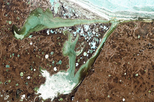
English: Natural-colour image of the Omulyakhskaya and Khromskaya Bays, Russia. The land around the bays is dotted with thermokarst lakes, which result from water released by thawing permafrost. The water in a thermokarst lake doesn’t always stay put; these lakes can melt through the surrounding permafrost and drain into a nearby water body, especially if it sits at a slightly lower elevation. This appears to have occurred in multiple lakes between the bays shown above. (The compound lakes are identifiable by their uneven margins.) Coastal erosion and river migration also can deplete the lakes. Dark brown spots, especially numerous east of Khromskaya Bay, are probably locations of former thermokarst lakes.
Image captured by the Thematic Mapper on the Landsat 5 satellite. Landsat data provided by the United States Geological Survey. Français : Image en couleurs naturelles des baies d’Omulyakhskaya et de Khromskaya (Russie). On distingue autour de ces baies une constellation de lacs thermokarstiques, résultant de l'eau libérée par le dégel du pergélisol. L’eau d’un lac thermokarst peut brutalement disparaitre à travers le pergélisol environnant et se déverser dans un plan d'eau voisin, surtout s'il se trouve à une altitude légèrement inférieure. Cela semble s'être produit dans plusieurs de slacs situés sur cette image (Les lacs composés sont identifiables par leurs marges inégales.) L'érosion côtière et la migration des rivières peuvent aussi vider des lacs. Les taches brun foncé, particulièrement nombreuses à l'est de la baie de Khromskaya, sont probablement des emplacements d'anciens lacs thermokarstiques. Image capturée par le Thematic Mapper sur le satellite Landsat 5. Données Landsat fournies par le United States Geological Survey. |
| Дата | |
| Источник | NASA Earth Observatory |
| Автор | Jesse Allen and Robert Simmon |
| Другие версии |
Лицензирование
| Этот файл находится в общественном достоянии (англ. public domain), так как он был создан NASA (Национальным управлением по аэронавтике и исследованию космического пространства). Политика авторского права NASA гласит, что «Материал NASA не защищается авторским правом, если не указано иное». (См. Template:PD-USGov, страницу политики авторского права NASA или политику использования изображений JPL.) | ||
 |
Предупреждения:
|
| Аннотации | Это изображение аннотировано: Просмотреть аннотации на Викискладе |
История файла
Нажмите на дату/время, чтобы посмотреть файл, который был загружен в тот момент.
| Дата/время | Миниатюра | Размеры | Участник | Примечание | |
|---|---|---|---|---|---|
| текущий | 13:39, 14 августа 2011 | | 4696 × 3131 (4,69 МБ) | Originalwana | {{Information |Description ={{en|1=Natural-colour image of the Omulyakhskaya and Khromskaya Bays. The land around the bays is dotted with thermokarst lakes, which result from water released by thawing permafrost. The water |
Использование файла
Нет страниц, использующих этот файл.
Глобальное использование файла
Данный файл используется в следующих вики:
- Использование в arz.wikipedia.org
- Использование в be.wikipedia.org
- Использование в bg.wikipedia.org
- Использование в ceb.wikipedia.org
- Использование в cs.wikipedia.org
- Использование в de.wikipedia.org
- Использование в en.wikipedia.org
- Использование в es.wikipedia.org
- Использование в fa.wikipedia.org
- Использование в it.wikipedia.org
- Использование в pl.wikipedia.org
- Использование в tr.wikipedia.org
- Использование в uk.wikipedia.org
- Использование в www.wikidata.org