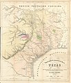
Файл:Roemer Topographisch-Geognostiche Karte von Texas 1849 UTA.jpg

Исходный файл(5826 × 6764 пкс, размер файла: 11,85 МБ, MIME-тип: image/jpeg)

Краткое описание

Название
Deutsch: Topographisch-Geognostische Karte von Texas
Описание
English: Dr. Ferdinand von Roemer's 1849 map of Texas contains considerable information about trails and roads in Texas in addition to other topographical, geological, and even botanical details. It is based upon A New & Correct Map of Texas by James T. D. Wilson, published by R. W. Fishbourne in New Orleans in 1845, a map based upon Texas General Land Office surveys that is quite rare today. Among the routes, trails, and roads depicted by Roemer's map, but also on Wilson's, are: the route of the Texan expedition to Santa Fe in the year 1841; the Chihuahua Trail; the road between Presidio and Nacogdoches; a number of roads in eastern, central, and south Texas; roads in western Louisiana and Arkansas; and even Preston road through Dallas and Bonham to the Red River. Interestingly, the roads labeled as ferries on the eastern side of Wilson's map ("Gaines' Ferry", "Junker's Ferry", "Ballou's Ferry") Von Roemer translates more properly into German as "Fähre" (or literally "trails").


Von Roemer (1818-1891), generally recognized today as the father of Texas geology, was a professor of paleontology from a prominent family in Hildesheim (at that time part of the Kingdom of Hanover) who came to Texas in late 1845 at the request of Baron Ottfried Hans von Meusebach, the Commissioner-General in Texas of the Adelsverein (a German Society of Nobles supporting German emigration to Texas). Von Roemer had the recommendations and financial support of members of the Berlin Academy of Sciences, including Baron Alexander von Humboldt and the great geologist and paleontologist Leopold von Buch. Von Roemer's task in Texas was to make a careful survey of the state, particularly focusing upon areas included in the Adelsverein grant. According to most scholars, he not only accomplished this in the eighteen months he spent here, but also his effort made significant contributions to geology, paleontology, and natural history.
Дата
Источник UTA Libraries Cartographic Connections: карта / текст
Создатель
Фердинанд Рёмер  (1818–1891)  wikidata:Q70854 s:en:Author:Carl Ferdinand von Roemer
 
Фердинанд Рёмер
Альтернативные имена
Рёмер, Фердинанд; Карл Фердинанд Рёмер; Рёмер, Карл Фердинанд; F.Roem.
Описание Германский ботаник, палеонтолог, преподаватель университета и геолог
Дата рождения/смерти 5 января 1818 Редактировать в Викиданных 14 декабря 1891 / 14 ноября 1891 Редактировать в Викиданных
Место рождения/смерти Хильдесхайм Вроцлав
Место творчества
Авторитетный файл
creator QS:P170,Q70854
Henry & Cohen, Bonn
Дополнительная информация
English: UTA Libraries Special Collections
 Geotemporal data
Map location Техас
Georeferencing Georeference the map in Wikimaps Warper If inappropriate please set warp_status = skip to hide.
 Bibliographic data
Публикация
Texas. Mit Besonderer Rücksicht auf Deutsche Auswanderung und die Physischen Verhältnisse des Landes
Автор
Фердинанд Рёмер  (1818–1891)  wikidata:Q70854 s:en:Author:Carl Ferdinand von Roemer
 
Фердинанд Рёмер
Альтернативные имена
Рёмер, Фердинанд; Карл Фердинанд Рёмер; Рёмер, Карл Фердинанд; F.Roem.
Описание Германский ботаник, палеонтолог, преподаватель университета и геолог
Дата рождения/смерти 5 января 1818 Редактировать в Викиданных 14 декабря 1891 / 14 ноября 1891 Редактировать в Викиданных
Место рождения/смерти Хильдесхайм Вроцлав
Место творчества
Авторитетный файл
creator QS:P170,Q70854
Место издания Бонн
Издательство
Adolph Marcus
 Archival data
institution QS:P195,Q1230739
Размеры высота: 56,5 см; ширина: 48,5 см
dimensions QS:P2048,56.5U174728
dimensions QS:P2049,48.5U174728
Техника colored литография на бумаге
artwork-references

Martin и Martin Maps of Texas and the Southwest, 1513-1900, № 35 , стр. 132−133

Geiser, Samuel Wood (1948) Naturalists of the Frontier, Dallas: SMU Press, стр. 148−171


Лицензирование

Public domain

Это произведение находится в общественном достоянии в тех странах, где срок охраны авторского права равен жизни автора плюс 100 лет и менее.


Это произведение находится в общественном достоянии (англ. public domain) в США, так как оно было опубликовано до 1 января 1929 года.

Краткие подписи

Добавьте однострочное описание того, что собой представляет этот файл

Элементы, изображённые на этом файле

изображённый объект

image/jpeg

История файла

Нажмите на дату/время, чтобы посмотреть файл, который был загружен в тот момент.

Дата/времяМиниатюраРазмерыУчастникПримечание
текущий17:52, 12 марта 2022Миниатюра для версии от 17:52, 12 марта 20225826 × 6764 (11,85 МБ)Michael Barera== {{int:filedesc}} == {{Map |title = {{de|'''''Topographisch-Geognostische Karte von Texas'''''}} |description = {{en|Dr. Ferdinand von Roemer's 1849 map of Texas contains considerable information about trails and roads in Texas in addition to other topographical, geological, and even botanical details. It is based upon ''A New & Correct Map of Texas'' by James T. D. Wilson, published by R. W. Fishbourne in New Orleans in 1845, a map based upon Texas General Land Office s...

Следующая страница использует этот файл:

Глобальное использование файла

Данный файл используется в следующих вики:

Метаданные