Файл:Russian-occupied Kherson Oblast administrative divisions.svg

Размер этого PNG-превью для исходного SVG-файла: 512 × 401 пкс. Другие разрешения: 307 × 240 пкс | 613 × 480 пкс | 981 × 768 пкс | 1280 × 1003 пкс | 2560 × 2005 пкс.
Исходный файл (SVG-файл, номинально 512 × 401 пкс, размер файла: 52 КБ)
Этот файл находится на Викискладе. Сведения о нём показаны ниже.
Викисклад — централизованное хранилище для свободных файлов, используемых в проектах Викимедиа.
|
Краткое описание
| Описание |
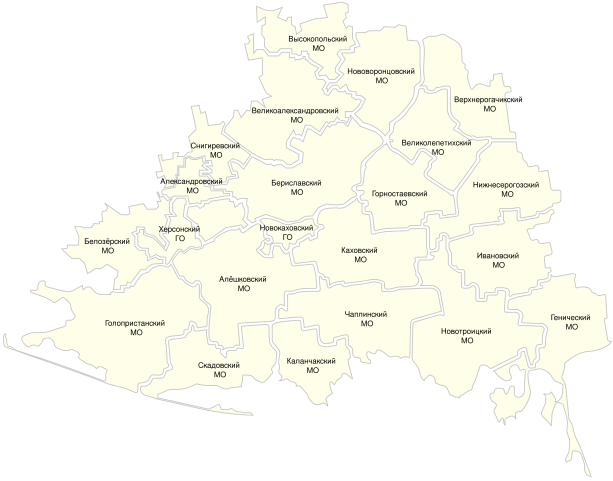
English: A map of Russia's claimed territory in Kherson Oblast and Mykolaiv Oblast, divided up into administrative divisions that were declared by the occupiers. |
| Дата | |
| Источник | https://khogov.ru/oblast/ |
| Автор | Unknown member of the occupation administration, then edited by me to clean up problems. |
Лицензирование
| This map is ineligible for copyright and therefore in the public domain, because it consists entirely of information that is common property and contains no original authorship. For more information, see Commons:Threshold of originality § Maps.
|
История файла
Нажмите на дату/время, чтобы посмотреть файл, который был загружен в тот момент.
| Дата/время | Миниатюра | Размеры | Участник | Примечание | |
|---|---|---|---|---|---|
| текущий | 17:59, 19 июня 2023 | | 512 × 401 (52 КБ) | HappyWithWhatYouHaveToBeHappyWith | Uploaded a work by Unknown member of the occupation administration, then edited by me to clean up problems. from https://khogov.ru/oblast/ with UploadWizard |
Использование файла
Следующая страница использует этот файл:
Глобальное использование файла
Данный файл используется в следующих вики:
- Использование в en.wikipedia.org
- Использование в www.wikidata.org