Файл:Sanson Amerique Septentrionale 1650 UTA.jpg

Размер этого предпросмотра: 800 × 561 пкс. Другие разрешения: 320 × 224 пкс | 640 × 448 пкс | 1024 × 718 пкс | 1280 × 897 пкс | 2560 × 1794 пкс | 3836 × 2688 пкс.
Исходный файл (3836 × 2688 пкс, размер файла: 1,89 МБ, MIME-тип: image/jpeg)
Этот файл находится на Викискладе. Сведения о нём показаны ниже.
Викисклад — централизованное хранилище для свободных файлов, используемых в проектах Викимедиа.
|
Краткое описание
| Название |
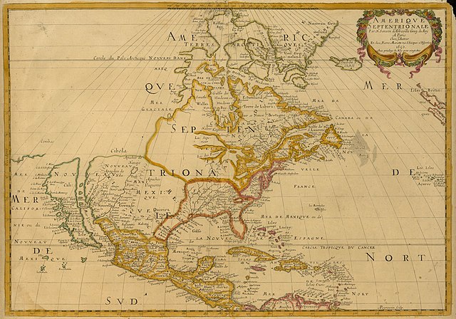
Français : Amerique Septentrionale |
||||||||||||||||||||||||||
| Описание |
English: Sanson's landmark 1650 map of North America includes interesting details relating to chartered company operations in the northern and eastern part of the continent as well as the Caribbean. Employing a sinusoidal projection, its construction demonstrates considerable scientific acumen. Much of the Great Lakes system now appears, with Lakes Superior and Ontario named for the first time. Sanson's sources must have included the annual reports of the Jesuits which included eyewitness accounts of their missionary activities and explorations in association with the chartered fur companies. These augmented the earlier explorations of Champlain. There is also "Mon Royal", or Montreal, laid out as a trading site by Champlain in 1611. "N[ouvelle]. Anglet[erre]" refers to New England, while "Nouvelle Amsterdam" and "Nouvelle Hollandia" on the east coast allude to activities there of the New Netherland Company (beginning in 1614) and the Dutch WIC (beginning in 1625). There is even "N[ouvelle]. Suede" relating to the new settlements in the Delaware Valley of the New Sweden Company chartered by the Swedish government in 1638. |
||||||||||||||||||||||||||
| Дата | или 1651 | ||||||||||||||||||||||||||
| Источник | UTA Libraries Cartographic Connections: карта / текст | ||||||||||||||||||||||||||
| Создатель |
|
||||||||||||||||||||||||||
| Дополнительная информация |
English: UTA Libraries Special Collections |
||||||||||||||||||||||||||
| Geotemporal data | |||||||||||||||||||||||||||
| Map location | Северная Америка | ||||||||||||||||||||||||||
| Georeferencing | If inappropriate please set warp_status = skip to hide. | ||||||||||||||||||||||||||
| Место издания | Париж | ||||||||||||||||||||||||||
| Archival data | |||||||||||||||||||||||||||
| Коллекция |
|
||||||||||||||||||||||||||
| Размеры | высота: 38 см; ширина: 54 см | ||||||||||||||||||||||||||
| Техника | colored гравюра | ||||||||||||||||||||||||||
| artwork-references |
Burden The Mapping of North America I, № 294 , стр. 375−377 Schwartz and Ralph Ehrenberg The Mapping of America, 5, № 61 , стр. 111−112 Hayes Historical Atlas of Canada, 1, стр. 60 Martin и Martin Maps of Texas and the Southwest, 1, стр. 82−83 |
||||||||||||||||||||||||||

Лицензирование

|
This file was provided to Wikimedia Commons by the University of Texas at Arlington Libraries as part of a cooperation project. The University of Texas at Arlington Libraries is part of the University of Texas at Arlington, a public research university located in Arlington, Texas.
|
|
Это произведение находится в общественном достоянии в тех странах, где срок охраны авторского права равен жизни автора плюс 100 лет и менее. Это произведение находится в общественном достоянии (англ. public domain) в США, так как оно было опубликовано до 1 января 1929 года. | |
| Этот файл был определён как свободный от известных ограничений авторского права, а также связанных и смежных прав. | |
История файла
Нажмите на дату/время, чтобы посмотреть файл, который был загружен в тот момент.
| Дата/время | Миниатюра | Размеры | Участник | Примечание | |
|---|---|---|---|---|---|
| текущий | 15:27, 8 февраля 2022 | | 3836 × 2688 (1,89 МБ) | Michael Barera | == {{int:filedesc}} == {{Map |title = {{la|'''''Amerique Septentrionale'''''}} |description = {{en|Sanson's landmark 1650 map of North America includes interesting details relating to chartered company operations in the northern and eastern part of the continent as well as the Caribbean. Employing a sinusoidal projection, its construction demonstrates considerable scientific acumen. Much of the Great Lakes system now appears, with Lakes Superior and Ontario named for the f... |
Использование файла
Следующая страница использует этот файл:
Глобальное использование файла
Данный файл используется в следующих вики:
- Использование в de.wikipedia.org
- Использование в en.wikipedia.org
- Использование в es.wikipedia.org
- Использование в fa.wikipedia.org
- Использование в it.wikipedia.org
- Использование в ja.wikipedia.org
- Использование в ko.wikipedia.org
- Использование в pt.wikipedia.org