Файл:Satellite image of South Island New Zealand.jpg
Размер этого предпросмотра: 487 × 599 пкс. Другие разрешения: 195 × 240 пкс | 390 × 480 пкс | 624 × 768 пкс | 832 × 1024 пкс | 1664 × 2048 пкс | 2600 × 3200 пкс.
Исходный файл (2600 × 3200 пкс, размер файла: 2,08 Мб, MIME-тип: image/jpeg)
Этот файл находится на Викискладе. Сведения о нём показаны ниже.
Викисклад — централизованное хранилище для свободных файлов, используемых в проектах Викимедиа.
|
| Описание |
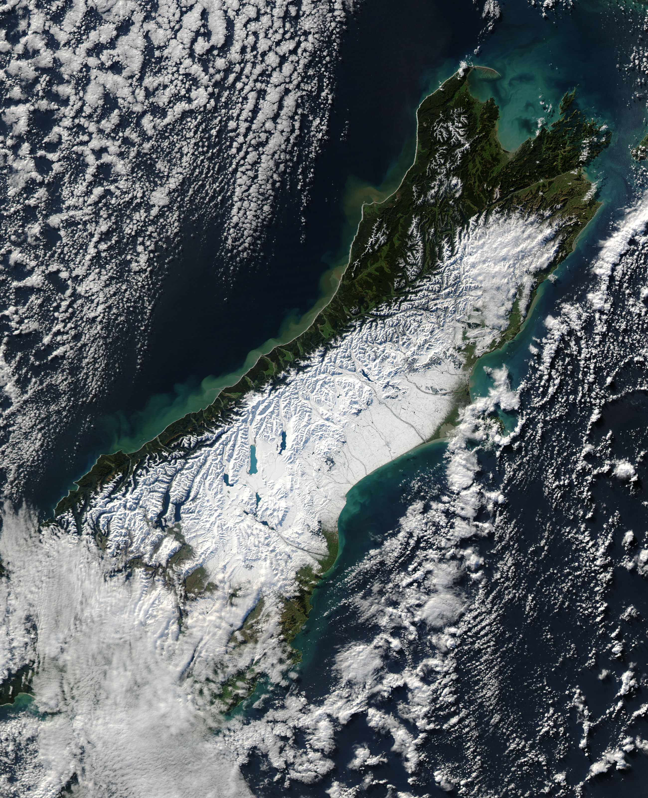
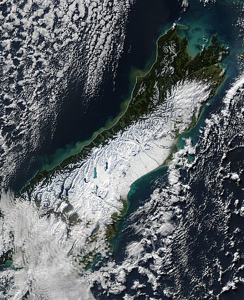
English: Satellite image of the South Island of New Zealand in June 2006. NASA's description:
Français : Une puissante tempête de neige balayant la Nouvelle-Zélande le 12 juin 2006. Selon l’Australian Broadcasting Corporation, la tempête amena de fortes rafales de vent atteignant 130 km/h et au moins une tornade. De fortes pluies provoquèrent des inondations et des glissements de terrain le long de la côte occidentale de l'île du Sud, la neige recouvrant la partie centrale de l'île.
Le 13 juin, lorsque l'imagerie produite par le spectromètre du satellite américain Aqua de la NASA, la neige recouvrait les Alpes du Sud, faisant ressortir les lacs des glaciers semblables à des doigts comme des saphirs sur un fond blanc. La neige atteint la mer du côté orientale de l'île. C'est ici, dans les bassins versants et les vallées à l'est des montagnes et autour de Christchurch, que la neige épaisse barra les routes et isola des communautés. Cette image montre également l'impacte des fortes précipitations le long de la côte occidentale de l'île du Sud. L'eau pleine de boue, chargée de sédiment provenant des glissements de terrain et des inondations, se déverse dans la mer de Tasmanie depuis les nombreux torrents qui s'écoulent des montagnes. |
|||||
| Дата | ||||||
| Источник | [1] | |||||
| Автор | NASA | |||||
| Права (Повторное использование этого файла) |
|

История файла
Нажмите на дату/время, чтобы посмотреть файл, который был загружен в тот момент.
| Дата/время | Миниатюра | Размеры | Участник | Примечание | |
|---|---|---|---|---|---|
| текущий | 11:47, 20 июня 2006 | | 2600 × 3200 (2,08 Мб) | Brian | {{PD-USGov-NASA}} Satellite image of the w:South Island of w:New Zealand in June 2005. NASA's description: :A powerful winter storm swept across New Zealand on June 12, 2006. The storm brought strong winds that gusted up to 130 kilometers per h |
Использование файла
Следующая страница использует этот файл:
Глобальное использование файла
Данный файл используется в следующих вики:
- Использование в af.wikipedia.org
- Использование в en.wikipedia.org
- Использование в es.wikipedia.org
- Использование в fr.wikipedia.org
- Использование в sl.wikipedia.org
- Использование в vi.wikipedia.org