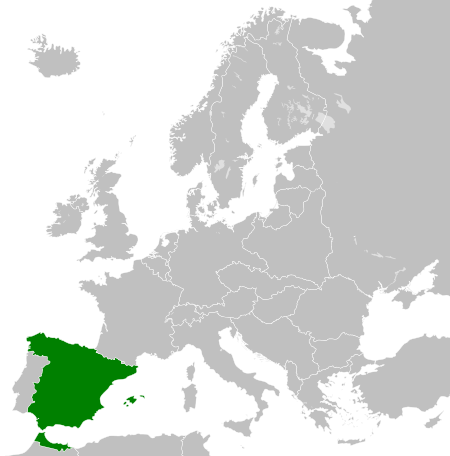
Файл:Spanish Republic (1936).svg

Размер этого PNG-превью для исходного SVG-файла: 450 × 456 пкс. Другие разрешения: 237 × 240 пкс | 474 × 480 пкс | 758 × 768 пкс | 1011 × 1024 пкс | 2021 × 2048 пкс.
Исходный файл (SVG-файл, номинально 450 × 456 пкс, размер файла: 475 КБ)
Этот файл находится на Викискладе. Сведения о нём показаны ниже.
Викисклад — централизованное хранилище для свободных файлов, используемых в проектах Викимедиа.
Сообщить об ошибке с файлом |
Краткие подписи
Добавьте однострочное описание того, что собой представляет этот файл
Элементы, изображённые на этом файле
изображённый объект
У этого свойства есть некоторое значение без элемента в
24 мая 2013
История файла
Нажмите на дату/время, чтобы посмотреть файл, который был загружен в тот момент.
| Дата/время | Миниатюра | Размеры | Участник | Примечание | |
|---|---|---|---|---|---|
| текущий | 07:52, 12 августа 2013 |  | 450 × 456 (475 КБ) | Alphathon | Fixed Yugoslav-Hungarian border (see main file) |
| 17:13, 25 июля 2013 |  | 450 × 456 (461 КБ) | Alphathon | Removed the Flevoland polders (Netherlands) which were not completed until 1942/1968 | |
| 20:38, 24 мая 2013 |  | 450 × 456 (461 КБ) | TRAJAN 117 | {{Information |Description ={{en|1=The Spanish Republic in 1936.}} |Source ={{own}} {{AttribSVG|Blank map of Europe 1929-1938.svg|Alphathon}} |Author =TRAJAN 117 {{created with Inkscape}} |Date =2013-05-... |
Использование файла
Следующая страница использует этот файл:
Глобальное использование файла
Данный файл используется в следующих вики:
- Использование в de.wikipedia.org
- Использование в en.wikipedia.org
- Использование в hu.wikipedia.org
- Использование в it.wikipedia.org
- Использование в ms.wikipedia.org
- Использование в zh.wikipedia.org
Метаданные
Файл содержит дополнительные данные, обычно добавляемые цифровыми камерами или сканерами. Если файл после создания редактировался, то некоторые параметры могут не соответствовать текущему изображению.
| Краткое название | Countries of Europe |
|---|---|
| Название изображения | A blank Map of Europe. Every country has an id which is its ISO-3166-1-ALPHA2 code in lower case.
Members of the EU have a class="eu", countries in europe (which I found turkey to be but russia not) have a class="europe".
Certain countries are further subdivided the United Kingdom has gb-gbn for Great Britain and gb-nir for Northern Ireland. Russia is divided into ru-kgd for the Kaliningrad Oblast and ru-main for the Main body of Russia. There is the additional grouping #xb for the "British Islands" (the UK with its Crown Dependencies - Jersey, Guernsey and the Isle of Man)

Contributors.
Original Image: (http://commons.wikimedia.org/wiki/Image:Europe_countries.svg) Júlio Reis (http://commons.wikimedia.org/wiki/User:Tintazul).
Recolouring and tagging with country codes: Marian "maix" Sigler (http://commons.wikimedia.org/wiki/User:Maix)
Improved geographical features: http://commons.wikimedia.org/wiki/User:W!B:
Updated to reflect dissolution of Serbia & Montenegro: http://commons.wikimedia.org/wiki/User:Zirland
Updated to include British Crown Dependencies as seperate entities and regroup them as "British Islands", with some simplifications to the XML and CSS: James Hardy (http://commons.wikimedia.org/wiki/User:MrWeeble)
Released under CreativeCommons Attribution ShareAlike (http://creativecommons.org/licenses/by-sa/2.5/). |
| Ширина | 450 |
| Высота | 456 |


