Исходный файл(SVG-файл, номинально 1014 × 944 пкс, размер файла: 2,6 Мб)

Краткое описание

Описание
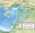
English: Following the defeath of Antiochus VII (died 129 BC) against Pathia, Syria contracted to the west of the Euphrates.[1] Parthia established the river as its western border and included Osroene.[2] To the north, the kingdom of Commagene bordered the Euphrates in the East, Cappadocia in the north (and included Melitene (Malatya) in its borders), the Amanus range in the west and Syria in the south (where Zeugma was the first Syrian city).[3] In the west, Cilicia between the Calycadnus river (Göksu) and the Orontes valley was under the rule of the Seleucids;[4][5] the Romans established a province of Cilicia in 102 BC but it did not include areas geographically in the region and the city of Side was the eastern point of that province.[6] In the south, Galilee fell to Judae except for the coastal city Ptolemais (Acre);[7][8] the latter remained part of Syria until the end of the Seleucid dynasty in 64 BC,[9] and it was the base for Antiochus X's widow Cleopatra Selene,[10] who was probably a resident of the city when her husband died.[11] Eastern Jordan was shared between the Nabateans and Judae whose king Alexander Jannaeus conquered Gadara in 100 BC.[12][13]
Дата
Источник SVG version of Attar-Aram syria's Syria under the Seleucids 95 BC.jpg
Автор Constantine Plakidas

Лицензирование

Я, владелец авторских прав на это произведение, добровольно публикую его на условиях следующей лицензии:
w:ru:Creative Commons
атрибуция распространение на тех же условиях
Этот файл доступен по лицензии Creative Commons Attribution-Share Alike 4.0 International
Вы можете свободно:
  • делиться произведением – копировать, распространять и передавать данное произведение
  • создавать производные – переделывать данное произведение
При соблюдении следующих условий:
  • атрибуция – Вы должны указать авторство, предоставить ссылку на лицензию и указать, внёс ли автор какие-либо изменения. Это можно сделать любым разумным способом, но не создавая впечатление, что лицензиат поддерживает вас или использование вами данного произведения.
  • распространение на тех же условиях – Если вы изменяете, преобразуете или создаёте иное произведение на основе данного, то обязаны использовать лицензию исходного произведения или лицензию, совместимую с исходной.
  1. Hogg, Hope W. (1911) "Mesopotamia" in The Encyclopedia Britannica: A Dictionary of Arts, Sciences, Literature and General Information, 18 (11‑й ed.), New York. Encyclopædia Britannica, Inc. 342 Madison Avenue, стр. 184 OCLC: 1303014.
  2. Kia, Mehrdad (2016) The Persian Empire. A Historical Encyclopedia, Empires of the World, 1, ABC-CLIO, стр. 55 ISBN: 978-1-61069-390-5.
  3. Goell, Theresa (1996) "Ancient Sources and Previous Scholarship" in Sanders, Donald H. , ed. Nemrud Dagi. The Hierothesion of Antiochus I of Commagene - Results of the American Excavations, 1: Texts, Eisenbrauns, стр. 22 ISBN: 978-1-57506-015-6.
  4. (1988). "A Hoard of Aegean Tetradrachms and the Autonomous Tetradrachms of Elaeusa Sebast". Museum Notes 33: 85. The American Numismatic Society. ISSN 0145-1413.
  5. (2009). "Seleucid Campaign Beards". L'Antiquité Classique 78. l’asbl L’Antiquité Classique. ISSN 0770-2817.
  6. (2011). "The Route Taken by Cilicia to Provincial Status: When and Why?". Olba: The Journal of Research Center for Cilician Archaeology 19: 268, 273. Mersin University Publicattions of the Research Center of Cilician Archaeology [KAAM]. ISSN 7667 1301 7667.
  7. Chancey, Mark A. (2002) The Myth of a Gentile Galilee, Society for New Testament Studies Monograph Series, 118, Cambridge University Press, стр. 45 ISBN: 978-0-511-48792-7.
  8. Smallwood, E. Mary (1976) The Jews Under Roman Rule: From Pompey to Diocletian, Brill, стр. 15 ISBN: 978-90-04-04491-3.
  9. Goldmann, Zeev (1975) [1970] "Accho" , 1, Prentice-Hall, стр. 15 ISBN: 978-0-132-75115-5.
  10. Kadman, Leo (1961) The Coins of Akko Ptolemais, Corpus nummorum Palaestinensium, IV, Schocken Publishing House, стр. 21 OCLC: 716861188.
  11. Whitehorne, John (1994) Cleopatras, Routledge, стр. 169 ISBN: 978-0-415-05806-3.
  12. Rababeh, Shaher Moh'd Ahmad (2006) How Petra was Built: an Analysis of the Construction Techniques of the Nabataean Freestanding Buildings and Rock-Cut Monuments in Petra, Jordan, British Archaeological Reports International Series, 1460, BAR Publishing, стр. 10 ISBN: 978-1-841-71898-9.
  13. "Gadara (Irbid, Jordan)" in (1996) International Dictionary of Historic Places, 4 (Middle East and Africe), Fitzroy Dearborn Publishers, стр. 284 ISBN: 978-1-884964-03-9.

Краткие подписи

Добавьте однострочное описание того, что собой представляет этот файл

Элементы, изображённые на этом файле

изображённый объект

У этого свойства есть некоторое значение без элемента в

История файла

Нажмите на дату/время, чтобы посмотреть файл, который был загружен в тот момент.

Дата/времяМиниатюраРазмерыУчастникПримечание
текущий16:42, 30 июня 2018Миниатюра для версии от 16:42, 30 июня 20181014 × 944 (2,6 Мб)Cplakidasfixing things missed from original map: correcting border at Gadara; adding Galilee as a region, changing Judea to font denoting a state; adding Nisibis
16:35, 30 июня 2018Миниатюра для версии от 16:35, 30 июня 20181014 × 944 (2,59 Мб)CplakidasUser created page with UploadWizard

Следующая страница использует этот файл:

Глобальное использование файла

Данный файл используется в следующих вики:

Метаданные