Файл:NASA fiordland 2009 earthquake.png
NASA_fiordland_2009_earthquake.png (720 × 480 пкс, размер файла: 363 КБ, MIME-тип: image/png)
Этот файл находится на Викискладе. Сведения о нём показаны ниже.
Викисклад — централизованное хранилище для свободных файлов, используемых в проектах Викимедиа.
|
Краткое описание
| Описание |
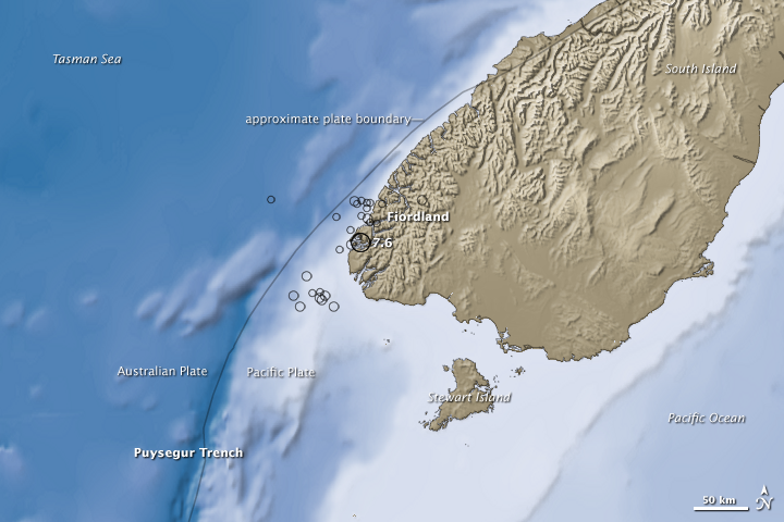
English: NASA Earth Observatory: map showing epicentre of 2009 New Zealand South Island fiordland earthquake. A 7.6-magnitude earthquake along the southwest coast of the South Island of New Zealand on July 15, 2009, was a dramatic reminder that the area is part of the Pacific Ring of Fire. Less nerve-rattling evidence of the area’s tectonic activity is revealed in this image of the bathymetry (shades of blue) and topography (shades of brown) of the southwestern part of the South Island, known as Fiordland, and the surrounding waters of the Tasman Sea and Pacific Ocean. Earth’s solid crust is broken into more than a dozen slabs, or plates, that drift slowly around the planet. Around New Zealand, the Australia Plate collides with the Pacific Plate; the approximate boundary is traced with a black line on this image. The pressure of the collision is released in complicated ways, creating fracture zones, deep trenches, and high mountains. Near and south of Fiordland, the Australia Plate is being forced below (subducted) the Pacific Plate at the Puysegur Trench, which is more than 5,000 meters (16,404 feet) deep. North of Fiordland, the two plates collide and grind past each other; the pressure of the colliding plates is raising the Southern Alps. Earthquakes occur because tectonic plates don’t simply slide smoothly past or over each other. They are pressed together with tremendous force, and they can be become temporarily stuck together, while the pressure builds. For a time, the crust can bend or stretch under the strain like a tree branch bends under the weight of heavy snow, but eventually the rocks break and the energy is released. According to the U.S. Geological Survey, the July 15 quake and its aftershocks (locations and magnitudes indicated by circles) occurred in the subduction part of the Australia-Pacific plate boundary. Phone lines and some buildings were damaged, and a small tsunami occurred, but no fatalities were reported, according to news reports. |
| Источник | Online source: http://earthobservatory.nasa.gov/IOTD/view.php?id=39415&src=eoa-iotd |
| Автор |
NASA image created by Jesse Allen, using earthquake and plate tectonics data from the USGS Earthquake Hazard Program, elevation data from the Shuttle Radar Topography Mission (SRTM) courtesy of the University of Maryland’s Global Land Cover Facility, and ocean bathymetry data from the National Oceanic and Atmospheric Administration’s (NOAA) ETOP1 global relief model of Earth’s surface. Caption by Rebecca Lindsey. |
| Права (Повторное использование этого файла) |
NASA image |
Лицензирование
| Этот файл находится в общественном достоянии (англ. public domain), так как он был создан NASA (Национальным управлением по аэронавтике и исследованию космического пространства). Политика авторского права NASA гласит, что «Материал NASA не защищается авторским правом, если не указано иное». (См. Template:PD-USGov, страницу политики авторского права NASA или политику использования изображений JPL.) | ||
 |
Предупреждения:
|
Исходный журнал загрузок
Перенесено с en.wikipedia на Викисклад участником The Bushranger при помощи CommonsHelper.
- 2009-07-26 12:45 Jasper33 720×480× (371431 bytes) NASA Earth Observatory: map showing epicentre of 2009 New Zealand South Island fiordland earthquake. Online source: http://earthobservatory.nasa.gov/IOTD/view.php?id=39415&src=eoa-iotd
История файла
Нажмите на дату/время, чтобы посмотреть файл, который был загружен в тот момент.
| Дата/время | Миниатюра | Размеры | Участник | Примечание | |
|---|---|---|---|---|---|
| текущий | 05:03, 22 июня 2012 | | 720 × 480 (363 КБ) | File Upload Bot (Magnus Manske) | Transfered from en.wikipedia by User:The Bushranger using CommonsHelper |
Использование файла
Следующая страница использует этот файл:
Глобальное использование файла
Данный файл используется в следующих вики:
- Использование в en.wikipedia.org
- Использование в es.wikipedia.org
- Использование в www.wikidata.org