Файл:Cannery processing building, left and office store right. Tkane from dock - Kake Salmon Cannery, 540 Keku Road, Kake, Wrangell-Petersburg Census Area, AK HAER AK,22-KAKE,2-9.tif

Размер этого JPG-превью для исходного TIF-файла: 800 × 581 пкс. Другие разрешения: 320 × 233 пкс | 640 × 465 пкс | 1024 × 744 пкс | 1280 × 930 пкс | 2560 × 1861 пкс | 5011 × 3642 пкс.
Исходный файл (5011 × 3642 пкс, размер файла: 17,41 МБ, MIME-тип: image/tiff)
Этот файл находится на Викискладе. Сведения о нём показаны ниже.
Викисклад — централизованное хранилище для свободных файлов, используемых в проектах Викимедиа.
|
Краткое описание
| Cannery processing building, left and office store right. Tkane from dock - Kake Salmon Cannery, 540 Keku Road, Kake, Wrangell-Petersburg Census Area, AK | ||||
|---|---|---|---|---|
| Фотограф |
Lowe, Jet Related names:
|
|||
| Название |
Cannery processing building, left and office store right. Tkane from dock - Kake Salmon Cannery, 540 Keku Road, Kake, Wrangell-Petersburg Census Area, AK |
|||
| Изображённое место | Alaska; Wrangell-Petersburg Census Area; Kake | |||
| Дата | 2000 | |||
| Техника | 5 x 7 in. | |||
| Текущее местонахождение |
Library of Congress Prints and Photographs Division Washington, D.C. 20540 USA http://hdl.loc.gov/loc.pnp/pp.print |
|||
| Инвентарный номер |
HAER AK,22-KAKE,2-9 |
|||
| Дополнительная информация |
|
|||
| Примечания |
|
|||
| Ссылки |
|
|||
| Источник | https://www.loc.gov/pictures/item/ak0330.photos.190608p | |||
| Права (Повторное использование этого файла) |
|
|||

| Местоположение объекта | | Это и другие изображения по их местоположению на OpenStreetMap |
|---|
История файла
Нажмите на дату/время, чтобы посмотреть файл, который был загружен в тот момент.
| Дата/время | Миниатюра | Размеры | Участник | Примечание | |
|---|---|---|---|---|---|
| текущий | 16:29, 25 июня 2014 | 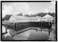 | 5011 × 3642 (17,41 МБ) | Fæ | GWToolset: Creating mediafile for Fæ. HABS batch upload start 25 June 2014 |
Использование файла
Следующая страница использует этот файл: