Файл:Elevation view of Theodore Roosevelt statue - Theodore Roosevelt Island, Potomac River, Washington, District of Columbia, DC HALS DC-12-31.tif

Исходный файл (3815 × 5338 пкс, размер файла: 19,42 МБ, MIME-тип: image/tiff)
Этот файл находится на Викискладе. Сведения о нём показаны ниже.
Викисклад — централизованное хранилище для свободных файлов, используемых в проектах Викимедиа.
|
Краткое описание
| Elevation view of Theodore Roosevelt statue - Theodore Roosevelt Island, Potomac River, Washington, District of Columbia, DC | ||||
|---|---|---|---|---|
| Фотограф |
Rosenthal, James W. Related names:
|
|||
| Название |
Elevation view of Theodore Roosevelt statue - Theodore Roosevelt Island, Potomac River, Washington, District of Columbia, DC |
|||
| Изображённое место | District of Columbia; District of Columbia; Washington | |||
| Дата | 2007 | |||
| Размеры | 5 x 7 in. | |||
| Текущее местонахождение |
Library of Congress Prints and Photographs Division Washington, D.C. 20540 USA http://hdl.loc.gov/loc.pnp/pp.print |
|||
| Инвентарный номер |
HALS DC-12-31 |
|||
| Дополнительная информация |
|
|||
| Примечания |
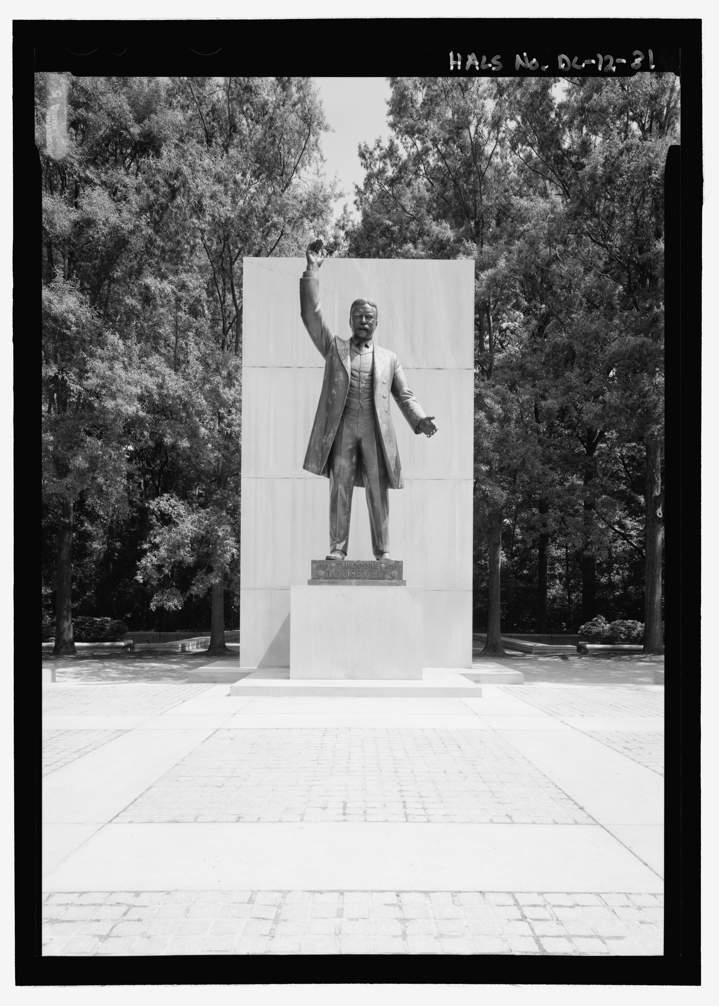
Archeological evidence shows that the island was in use by the area’s Native American tribes from prehistory until the early eighteenth century. Furthermore, the island’s alternate name of Analostan likely originated through an association with the Necostin (Anacostian) Indians. In 1717, Revolutionary Patriot George Mason IV, author of the Virginia Bill of Rights, acquired the Island and established a ferry there in 1748. His son, John Mason, developed the island as a plantation estate and built a causeway connecting with the Virginia coast and a large Federal-style mansion, also named Analostan. The alternate historical name of Mason’s Island stems from the Mason family’s ownership of the site. Later, during the Civil War, Union forces occupied Theodore Roosevelt Island. During the summer of 1863 the island functioned as the camp of the 1st United States Colored Troops, an African American regiment composed of free blacks and escaped slaves. From May 1864-June 1865 a freedmen’s refugee camp occupied much of the island, including the Mason mansion. Following a long period of transient ownership, short-term tenancy, and disuse, the Roosevelt Memorial Association (RMA) purchased the island in 1931 as a national memorial to the former president. The following year the RMA gave the island to the federal government, but maintained planting and development rights. Between 1934-1945 the RMA retained renowned landscape architect Frederick Law Olmsted, Jr. to replant the island as a planned wilderness “to be preserved as nearly as possible as in its natural state.” This concept of designed nature is significant in that it forces people to rethink the human relationship with the natural world, and indeed, what constitutes nature. Less abstractly, the planting plan, carried out by Civilian Conservation Corps (CCC) workers, “represents one of the most complete expressions of Olmsted’s ideals on scenic preservation, through his attempt to recreate the island’s presumed former appearance so that it could continue its natural evolution to a stable, ‘climax’ forest.” Finally, Gugler’s plaza and Manship’s Theodore Roosevelt sculpture represent a distinct step in the development of presidential memorials within Washington, D.C.
|
|||
| Ссылки |
|
|||
| Источник | https://www.loc.gov/pictures/item/dc1044.photos.362658p | |||
| Права (Повторное использование этого файла) |
|
|||

| Местоположение объекта | | Это и другие изображения по их местоположению на OpenStreetMap |
|---|
История файла
Нажмите на дату/время, чтобы посмотреть файл, который был загружен в тот момент.
| Дата/время | Миниатюра | Размеры | Участник | Примечание | |
|---|---|---|---|---|---|
| текущий | 00:03, 10 июля 2014 |  | 3815 × 5338 (19,42 МБ) | Fæ | GWToolset: Creating mediafile for Fæ. HABS 09 July 2014 (801:1000) |
Использование файла
Следующая страница использует этот файл: