Файл:Centroamerica prehispanica siglo XVI.svg

Размер этого PNG-превью для исходного SVG-файла: 800 × 528 пкс. Другие разрешения: 320 × 211 пкс | 640 × 423 пкс | 1024 × 676 пкс | 1280 × 845 пкс | 2560 × 1691 пкс | 250 980 × 165 770 пкс.
Исходный файл (SVG-файл, номинально 250 980 × 165 770 пкс, размер файла: 499 КБ)
Этот файл находится на Викискладе. Сведения о нём показаны ниже.
Викисклад — централизованное хранилище для свободных файлов, используемых в проектах Викимедиа.
|
Краткое описание
| Описание |
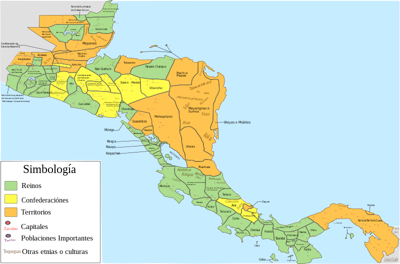
Español: Mapa de las diferentes entidades territoriales que existían en Centroamérica en el siglo XVI antes de la llegada de los españoles. En lo referente a la simbología, se tomaron en cuenta las siguientes consideraciones: Reinos, todas aquellas entidades territoriales (llamadas comúnmente señoríos o cacicazgos) que contaban con una capital y un señor principal; confederación, todas aquellas entidades conformadas por señoríos o poblaciones que aunque eran independientes tenían algún tipo de integración o alianza; territorio, todas aquellas regiones conformadas por varios señoríos o poblaciones (ya sean sedentarias, nómadas o seminómadas) que no contaban con algún tipo de integración o alianza, y de las que hay nula o escasa información de como estaban constituidos o de como se encontraban delimitados los territorios de todos o algunas entidades que se encontraban en esa región; como poblaciones importantes se toman en cuenta aquellas poblaciones que eran parte de la organización administrativa de alguna entidad, aquellas poblaciones que tuvieron un papel destacado en la conquista española de alguna entidad (como aquellas en las que se libraron batallas importantes), y las poblaciones donde se hablaban o donde aún se hablan algunas lenguas o dialectos; por último, es de mencionar que las otras etnias o culturas mostradas podrían haber estado sometidas a la entidad donde se mencionan o podrían ser independientes de dicha entidad
English: Map of the different territorial entities that existed in Central America in the XVI century before the arrive of the spanish people. With regard to symbology, the following considerations were taken: "reino" (Kingdoms), all those territorial entities (commonly called "señoríos" (lordships) or "cacicazgos") that had a capital and a principal lord; "confederación" (confederation), all those entities conformed by "señoríos" or towns that although they were independent had some type of integration or alliance; "territorio" (territory), all those regions conformed by several "señoríos" or towns (whether sedentary, nomadic or semi-nomadic) that did not count on some type of integration or alliance, and of which there is null or little information of how they were constituted or as were delimited the territories of all or someone entities that were in that region; on the other hand, as important towns are mentioned those towns that were part of the administrative organization of some entity, those towns that had a prominent role in the Spanish conquest of some entity (such as those in which important battles were fought), and the localities where some languages or dialects were spoken, or where they are still spoken today; Finally, it is worth mentioning that the other ethnic groups or cultures shown could have been submitted to the entity where they are mentioned or could be independent of said entity. |
| Дата | |
| Источник |
Собственная работа, for the elaboration of this picture were used the next resources: This file of wikimedia commons was used for great part of Costa Rica:  And, pictures or information of the nexts documents, publications or books:
|
| Автор | Juan Miguel |
Лицензирование
Я, владелец авторских прав на это произведение, добровольно публикую его на условиях следующей лицензии:
Этот файл доступен по лицензии Creative Commons Attribution-Share Alike 3.0 Unported.
- Вы можете свободно:
- делиться произведением – копировать, распространять и передавать данное произведение
- создавать производные – переделывать данное произведение
- При соблюдении следующих условий:
- атрибуция – Вы должны указать авторство, предоставить ссылку на лицензию и указать, внёс ли автор какие-либо изменения. Это можно сделать любым разумным способом, но не создавая впечатление, что лицензиат поддерживает вас или использование вами данного произведения.
- распространение на тех же условиях – Если вы изменяете, преобразуете или создаёте иное произведение на основе данного, то обязаны использовать лицензию исходного произведения или лицензию, совместимую с исходной.
История файла
Нажмите на дату/время, чтобы посмотреть файл, который был загружен в тот момент.
| Дата/время | Миниатюра | Размеры | Участник | Примечание | |
|---|---|---|---|---|---|
| текущий | 06:23, 5 декабря 2022 | | 250 980 × 165 770 (499 КБ) | Juan Miguel | Arreglando algunos detalles |
| 08:34, 5 мая 2019 |  | 250 976 × 165 771 (664 КБ) | Juan Miguel | Arreglando tamaño de fuente de algunos textos | |
| 08:30, 5 мая 2019 |  | 250 976 × 165 771 (663 КБ) | Juan Miguel | Arreglando tamaño de fuente de algunos textos | |
| 08:25, 5 мая 2019 |  | 250 976 × 165 771 (663 КБ) | Juan Miguel | Arreglando algunos textos | |
| 06:18, 5 мая 2019 |  | 250 976 × 165 771 (661 КБ) | Juan Miguel | Agregó capitales y otras poblaciones importantes, con lo cuál también se mejora los límites entre varias entidades. Además se añaden otras etnias y culturas que pueden formar parte de dicha entidad o ser independientes, y finalmente se amplía la imagen para que los diversos elementos se han más visibles | |
| 05:16, 18 декабря 2018 |  | 15 744 × 11 093 (276 КБ) | Juan Miguel | Correcciones menores | |
| 10:52, 17 декабря 2018 |  | 15 744 × 11 093 (277 КБ) | Juan Miguel | Pequeñas correciones | |
| 03:02, 22 октября 2018 |  | 15 744 × 11 093 (278 КБ) | Juan Miguel | Arreglo menor en el cuadro de simbología | |
| 02:44, 22 октября 2018 |  | 15 744 × 11 093 (278 КБ) | Juan Miguel | Arreglo algunas fronteras, pongo colores claros, reduzco la cantidad de colores y año el cuadro de simbología. | |
| 10:13, 16 июля 2017 |  | 15 744 × 11 093 (274 КБ) | Juan Miguel | Arreglo algunas fronteras y agrego el nombre de los lagos y el color a los océanos. |
Использование файла
Следующая страница использует этот файл:
Глобальное использование файла
Данный файл используется в следующих вики:
- Использование в ar.wikipedia.org
- Использование в ast.wikipedia.org
- Использование в bn.wikipedia.org
- Использование в ca.wikipedia.org
- Использование в en.wikipedia.org
- Использование в es.wikipedia.org
- Historia de Panamá
- Historia de Honduras
- Historia de El Salvador
- Pipil
- Historia de Guatemala
- Historia de Nicaragua
- Historia de América Central
- Historia de Belice
- Señorío de Cuzcatlán
- Idioma náhuat
- Reino quiché de Q'umarkaj
- Usuario discusión:Montgomery/Archivo 15
- Chajoma
- Honduras prehispánica
- Historia precolombina de Honduras
- Historia territorial de Panamá
- Uluas
- Gran Darién
- Использование в eu.wikipedia.org
- Использование в fr.wikipedia.org
- Использование в gl.wikipedia.org
- Использование в io.wikipedia.org
- Использование в ja.wikipedia.org
- Использование в simple.wikipedia.org
- Использование в zh.wikipedia.org