Файл:Leigh Smith 1880 expedition map.tif
Исходный файл (4275 × 3657 пкс, размер файла: 15,04 МБ, MIME-тип: image/tiff)
Этот файл находится на Викискладе. Сведения о нём показаны ниже.
Викисклад — централизованное хранилище для свободных файлов, используемых в проектах Викимедиа.
|
Краткое описание
| Описание |
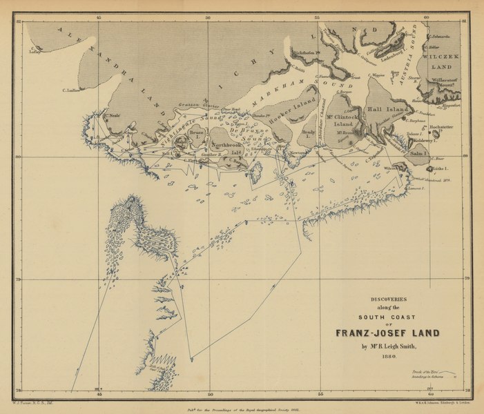
English: Route, direction, and dates of voyage are shown.
Ice sheets and icebergs along route shown in blue. Depth shown by soundings. Relief shown by hachures. Conjectural coastlines shown by broken lines. Site of abandonment of Tegetthoff [Austrian vessel] in 1874 is shown. Scale: ca. 1 : 9 200 000 From: Proceedings of the Royal Geographical Society and monthly record of geography. Vol. 3 (1881), no. 3, pp. 129-50 |
| Дата | |
| Источник | Maps and Geospatial Data, Princeton University Library |
| Автор | William John Turner |
Лицензирование
|
Это произведение находится в общественном достоянии в тех странах, где срок охраны авторского права равен жизни автора плюс 70 лет и менее. Это произведение находится в общественном достоянии (англ. public domain) в США, так как оно было опубликовано до 1 января 1929 года. | |
| Этот файл был определён как свободный от известных ограничений авторского права, а также связанных и смежных прав. | |
История файла
Нажмите на дату/время, чтобы посмотреть файл, который был загружен в тот момент.
| Дата/время | Миниатюра | Размеры | Участник | Примечание | |
|---|---|---|---|---|---|
| текущий | 00:33, 11 января 2021 |  | 4275 × 3657 (15,04 МБ) | Kaschelott | Uploaded a work by William John Turner from https://maps.princeton.edu/catalog/princeton-02870z378 with UploadWizard |
Использование файла
Следующая страница использует этот файл:
Глобальное использование файла
Данный файл используется в следующих вики:
- Использование в ca.wikipedia.org
- Использование в en.wikipedia.org
- Использование в es.wikipedia.org
- Использование в sv.wikipedia.org