Файл:Minnesota Congressional Districts, 113th Congress.tif

Размер этого PNG-превью для исходного TIF-файла: 554 × 600 пкс. Другие разрешения: 222 × 240 пкс | 443 × 480 пкс | 709 × 768 пкс | 946 × 1024 пкс | 1292 × 1399 пкс.
Исходный файл (1292 × 1399 пкс, размер файла: 519 КБ, MIME-тип: image/tiff)
Этот файл находится на Викискладе. Сведения о нём показаны ниже.
Викисклад — централизованное хранилище для свободных файлов, используемых в проектах Викимедиа.
|
Краткое описание
| Описание |
English: Map of Congressional Districts in the state of Minnesota, reflecting district boundaries current to the 113th United States Congress. |
| Дата | |
| Источник | National Atlas of the United States (http://nationalatlas.gov/printable/congress.html) |
| Автор | Department of the Interior |
Лицензирование
This map was obtained from an edition of the National Atlas of the United States. Like almost all works of the U.S. federal government, works from the National Atlas are in the public domain in the United States.
Online access: NationalAtlas.gov | 1970 print edition: Library of Congress, Perry-Castañeda Library
|
История файла
Нажмите на дату/время, чтобы посмотреть файл, который был загружен в тот момент.
| Дата/время | Миниатюра | Размеры | Участник | Примечание | |
|---|---|---|---|---|---|
| текущий | 06:00, 2 февраля 2014 | 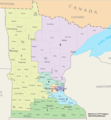 | 1292 × 1399 (519 КБ) | 7partparadigm | User created page with UploadWizard |
Использование файла
Следующие 2 страницы используют этот файл:
Глобальное использование файла
Данный файл используется в следующих вики:
- Использование в en.wikipedia.org
- Использование в fa.wikipedia.org
- Использование в uk.wikipedia.org
- Использование в zh.wikipedia.org